Werra-Meißner-Kreis – DE737
EU regions: Germany > Hesse > Kassel Government Region > Werra-Meißner-Kreis
| Indicator | Period | Value |
|---|---|---|
| Gross domestic product | ||
| GDP per capita in PPS of EU average | 2023 | 84 |
Werra-Meißner-Kreis slovensky: DE737
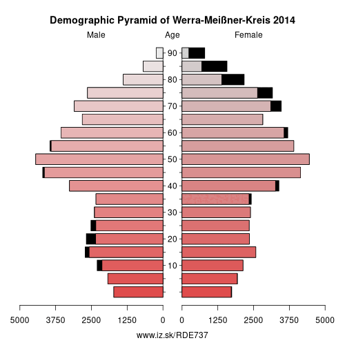
Demographics
| Indicator | Period | Value |
|---|---|---|
| Demographics | ||
| number of inhabitants | 2025 | 97 695 |
| population density | 2024 | 95.8 |
| old-age dependency ratio | 2025 | 44.5 |
From Wikipedia : Werra-Meißner is a Kreis (district) in the north of Hesse, Germany. Neighboring districts are Göttingen, Eichsfeld, Unstrut-Hainich-Kreis, Wartburgkreis, district-free Eisenach, Hersfeld-Rotenburg, Schwalm-Eder-Kreis, Kassel.
History
The district was created in 1974 by merging the two districts of Eschwege and Witzenhausen, which had both existed with only slight modifications since 1821.
Geography
The main river in the district is the Werra. The Hoher Meißner at 754 metres (2,474 ft) is the highest elevation of the Meißner mountains, a big basalt massif, the other geographical feature which gave the district its name.
The Hoher Meissner was also home to US military forces up to the fall of the Berlin Wall. Soldiers of the Special Forces guarded the eavesdropping post on the hilltop.See also: Wanfried agreement.
Other: Kassel Government Region, Waldeck-Frankenberg, Schwalm-Eder-Kreis, Hersfeld-Rotenburg, Landkreis Kassel, Fulda, Kassel, Werra-Meißner-Kreis
Neighbours: Eichsfeld, Schwalm-Eder-Kreis, Landkreis Kassel, Hersfeld-Rotenburg, Wartburgkreis, Unstrut-Hainich-Kreis, Göttingen district
Suggested citation: Michal Páleník: Europe and its regions in numbers - Werra-Meißner-Kreis – DE737, IZ Bratislava, retrieved from: https://www.iz.sk/PDE737, ISBN: 978-80-970204-9-1, DOI:10.5281/zenodo.10200164
 Share
Share Facebook
 Twitter
 News
News