Fulda – DE732
EU regions: Germany > Hesse > Kassel Government Region > Fulda
| Indicator | Period | Value |
|---|---|---|
| Gross domestic product | ||
| GDP per capita in PPS of EU average | 2023 | 110 |
Fulda slovensky: DE732
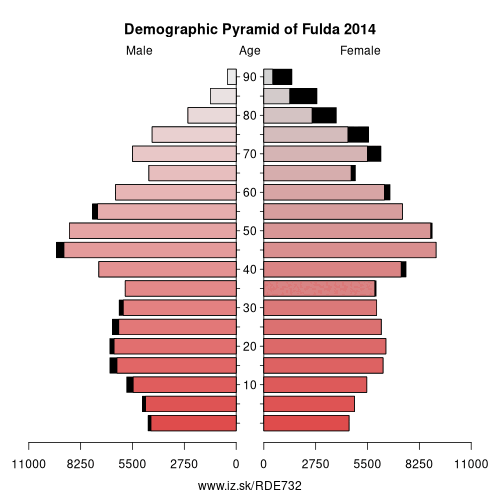
Demographics
| Indicator | Period | Value |
|---|---|---|
| Demographics | ||
| number of inhabitants | 2025 | 222 283 |
| population density | 2024 | 161.2 |
| old-age dependency ratio | 2025 | 35.9 |
Other: Kassel Government Region, Waldeck-Frankenberg, Schwalm-Eder-Kreis, Hersfeld-Rotenburg, Landkreis Kassel, Fulda, Kassel, Werra-Meißner-Kreis
Neighbours: Main-Kinzig-Kreis, Hersfeld-Rotenburg, Wartburgkreis, Schmalkalden-Meiningen, Rhön-Grabfeld, Bad Kissingen district, Vogelsbergkreis
Suggested citation: Michal Páleník: Europe and its regions in numbers - Fulda – DE732, IZ Bratislava, retrieved from: https://www.iz.sk/PDE732, ISBN: 978-80-970204-9-1, DOI:10.5281/zenodo.10200164
https://www.iz.sk/en/projects/eu-regions/DE732
 Share
Share Facebook
 Twitter
 News
News