Warendorf District – DEA38
EU regions: Germany > North Rhine-Westphalia > Münster Government Region > Warendorf District
| Indicator | Period | Value |
|---|---|---|
| Gross domestic product | ||
| GDP per capita in PPS of EU average | 2023 | 92 |
Warendorf District slovensky: DEA38
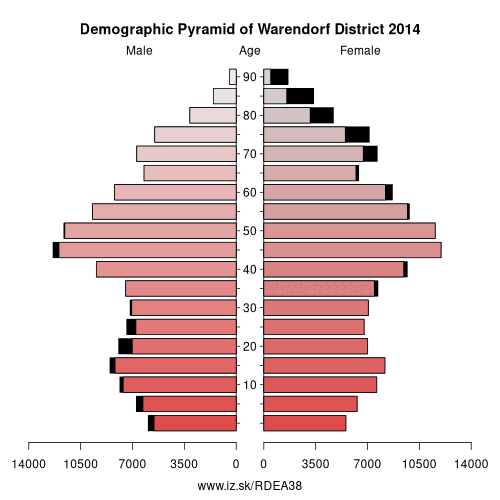
Demographics
| Indicator | Period | Value |
|---|---|---|
| Demographics | ||
| number of inhabitants | 2025 | 282 639 |
| population density | 2024 | 214.3 |
| old-age dependency ratio | 2025 | 36.4 |
Other: Münster Government Region, Steinfurt, Warendorf District, Bottrop, Coesfeld, Borken, Recklinghausen, Münster, Gelsenkirchen
Neighbours: Gütersloh, Soest, Coesfeld, Osnabrück District, Hamm, Münster, Steinfurt
Suggested citation: Michal Páleník: Europe and its regions in numbers - Warendorf District – DEA38, IZ Bratislava, retrieved from: https://www.iz.sk/PDEA38, ISBN: 978-80-970204-9-1, DOI:10.5281/zenodo.10200164
https://www.iz.sk/en/projects/eu-regions/DEA38
 Share
Share Facebook
 Twitter
 News
News