Styria – AT22
EU regions: Austria > Southern Austria > Styria
| Indicator | Period | Value |
|---|---|---|
| Life long learning | ||
| life long learning participation | 2025 | 16.1 |
| Part time jobs and flexible employment | ||
| percentage of part time workers | 2025 | 32.89 |
| percentage of part time workers, men | 2025 | 12.82 |
| percentage of part time workers, women | 2025 | 55.23 |
| Gender differences | ||
| gender gap in employment rate | 2025 | 92.28 |
| gender gap in unemployment rate | 2025 | 81.82 |
| Graduates and young people | ||
| unemployment rate of youth with elementary education | 2025 | 16.9 |
| NEET | 2025 | 10.6 |
| Gross domestic product | ||
| GDP per capita in PPS of EU average | 2024 | 111 |
| Employment | ||
| employment rate | 2025 | 74.7 |
| Social exclusion | ||
| people at risk of poverty or social exclusion | 2018 | 17.6 |
Styria slovensky: AT22
Subregions: Graz-Umgebung District, Liezen District, Östliche Obersteiermark, Oststeiermark, West- und Südsteiermark, Westliche Obersteiermark
Unemployment
| Indicator | Period | Value |
|---|---|---|
| Unemployment | ||
| unemployment rate | 2025 | 5.1 |
| youth unemployment rate | 2025 | 11.3 |
| Long term unemployment | ||
| long term unemployment | 2025 | 1 |
| share of long term unemployed | 2025 | 19.6 |
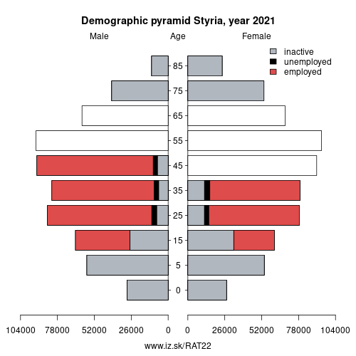
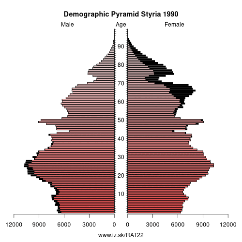
Demographics
| Indicator | Period | Value |
|---|---|---|
| Demographics | ||
| number of inhabitants | 2025 | 1 271 716 |
| population density | 2024 | 78.2 |
| old-age dependency ratio | 2025 | 34.2 |
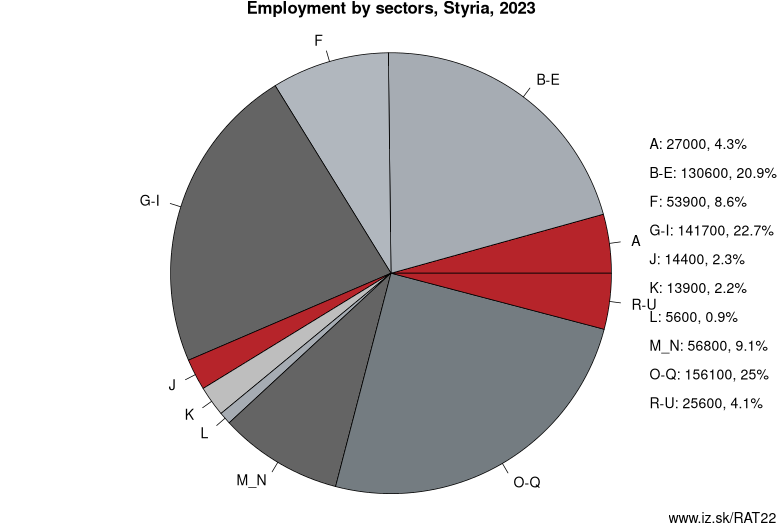
Employment by sectors, Styria
| NACE r2 | % | NACE r2 | % | ||
|---|---|---|---|---|---|
| A | 22.1 | 4% | B-E | 122.8 | 20% |
| F | 50 | 8% | G-I | 134.5 | 22% |
| J | 19.7 | 3% | K | 15.2 | 2% |
| L | 6.4 | 1% | M_N | 54.7 | 9% |
| O-Q | 163.6 | 27% | R-U | 27.1 | 4% |
| TOTAL | 616 | 100% |
Data for the period year 2025. Source of the data is Eurostat, table [lfst_r_lfe2en2].
From Wikipedia : Styria (German: Steiermark [ˈʃtaɪɐˌmaʁk] (listen); Croatian and Slovene: Štajerska; Hungarian: Stájerország; Czech: Štýrsko; Slovak: Štajersko) is a state, or Bundesland, located in the southeast of Austria. In area it is the second largest (after Lower Austria) of the nine Austrian federated states, covering 16,401 km2 (6,332 sq mi). It borders Slovenia (Carinthia Statistical Region, Drava Statistical Region and Mura Statistical Region) and the Austrian states of Upper Austria, Lower Austria, Salzburg, Burgenland, and Carinthia. The capital city is Graz which had 276,526 inhabitants at the beginning of 2015.
Etymology
The March of Styria derived its name from the original seat of its ruling Otakar dynasty: Steyr, in today's Upper Austria. In German, the area is still called „Steiermark" while in English the Latin name „Styria" is used. The ancient link between Steyr and Styria is also apparent in their nearly identical coats of arms, a white Panther on a green background.
Geography
The term "Upper Styria" (German: Obersteiermark) used by an Austrian refers to the northern and northwestern parts of the federal-state (districts Liezen, Murau, Judenburg, Knittelfeld, Leoben, Bruck an der Mur, and Mürzzuschlag). The term "West Styria" (Weststeiermark) is used for the districts to the west of Graz (Voitsberg, Deutschlandsberg, western part of the district Leibnitz); the districts east of Graz (Weiz, Hartberg, Feldbach, Fürstenfeld, and Radkersburg) are referred to as "East Styria" (Oststeiermark). The western and eastern parts of the district Graz-Umgebung may or may not be considered parts of West and East Styria, respectively.
Other: Southern Austria, Styria, Carinthia
Neighbours: Burgenland, Carinthia, Salzburg, Lower Austria, Eastern Slovenia, Upper Austria
Subregions: Graz-Umgebung District, Liezen District, Östliche Obersteiermark, Oststeiermark, West- und Südsteiermark, Westliche Obersteiermark
Suggested citation: Michal Páleník: Europe and its regions in numbers - Styria – AT22, IZ Bratislava, retrieved from: https://www.iz.sk/PAT22, ISBN: 978-80-970204-9-1, DOI:10.5281/zenodo.10200164
 Share
Share Facebook
 Twitter
 News
News