Burgenland – AT11
EU regions: Austria > East Austria > Burgenland
| Indicator | Period | Value |
|---|---|---|
| Life long learning | ||
| life long learning participation | 2025 | 13.5 |
| Part time jobs and flexible employment | ||
| percentage of part time workers | 2025 | 30.23 |
| percentage of part time workers, men | 2025 | 10.88 |
| percentage of part time workers, women | 2025 | 51.06 |
| Gender differences | ||
| gender gap in employment rate | 2025 | 91.86 |
| gender gap in unemployment rate | 2025 | 94.12 |
| Gross domestic product | ||
| GDP per capita in PPS of EU average | 2024 | 86 |
| Employment | ||
| employment rate | 2025 | 73.1 |
| Social exclusion | ||
| people at risk of poverty or social exclusion | 2018 | 14.6 |
Burgenland slovensky: AT11
Subregions: Oberpullendorf District, Nordburgenland, Südburgenland
Unemployment
| Indicator | Period | Value |
|---|---|---|
| Unemployment | ||
| unemployment rate | 2025 | 5 |
Demographics
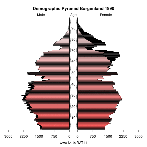
| Indicator | Period | Value |
|---|---|---|
| Demographics | ||
| number of inhabitants | 2025 | 301 790 |
| population density | 2024 | 79.8 |
| old-age dependency ratio | 2025 | 39.5 |
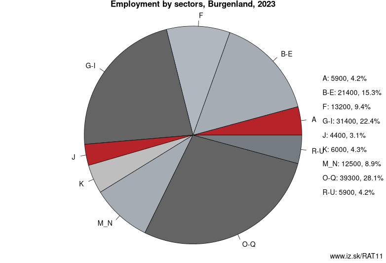
Employment by sectors, Burgenland
| NACE r2 | % | NACE r2 | % | ||
|---|---|---|---|---|---|
| A | 4.7 | 3% | B-E | 17.3 | 12% |
| F | 14.2 | 10% | G-I | 30.3 | 22% |
| J | 4.7 | 3% | K | 4.8 | 3% |
| M_N | 12.7 | 9% | O-Q | 42.6 | 31% |
| R-U | 6.3 | 5% | TOTAL | 139.4 | 100% |
Data for the period year 2025. Source of the data is Eurostat, table [lfst_r_lfe2en2].
From Wikipedia : Burgenland (German pronunciation: [ˈbʊʁɡn̩lant] (listen); Hungarian: Őrvidék; Croatian: Gradišće; Slovene: Gradiščanska; Czech: Hradsko; is the easternmost and least populous state of Austria. It consists of two statutory cities and seven rural districts, with in total 171 municipalities. It is 166 km (103 mi) long from north to south but much narrower from west to east (5 km (3.1 mi) wide at Sieggraben). The region is part of the Centrope Project.
Geography
Burgenland is the seventh largest of Austria's nine states, or Bundesländer, at 3,962 km2 (1,530 sq mi). The highest point in the province is on the Geschriebenstein, whose summit is 884 metres (2,900 ft) above sea level, but the highest point in Burgenland itself is 879 metres above sea level; the lowest point (which is also the lowest point of Austria) at 114 metres (374 ft), is in the municipal area of Apetlon.
Burgenland borders the Austrian state of Styria to the southwest, and the state of Lower Austria to the northwest. To the east it borders Hungary (Vas County and Győr-Moson-Sopron County). In the extreme north and south there are short borders with Slovakia (Bratislava Region) and Slovenia (Mura Statistical Region) respectively.
Burgenland and Hungary share the Neusiedler See (Hungarian: Fertő tó), a lake known for its reeds and shallowness, as well as its mild climate throughout the year.
Other: East Austria, Wien, Burgenland, Lower Austria
Neighbours: Styria, Lower Austria, Eastern Slovenia, Western Transdanubia, Bratislava Region
Subregions: Oberpullendorf District, Nordburgenland, Südburgenland
Suggested citation: Michal Páleník: Europe and its regions in numbers - Burgenland – AT11, IZ Bratislava, retrieved from: https://www.iz.sk/PAT11, ISBN: 978-80-970204-9-1, DOI:10.5281/zenodo.10200164
 Share
Share Facebook
 Twitter
 News
News