district Heidenheim – DE11C
EU regions: Germany > Baden-Württemberg > Stuttgart Government Region > district Heidenheim
| Indicator | Period | Value |
|---|---|---|
| Gross domestic product | ||
| GDP per capita in PPS of EU average | 2023 | 102 |
district Heidenheim slovensky: DE11C
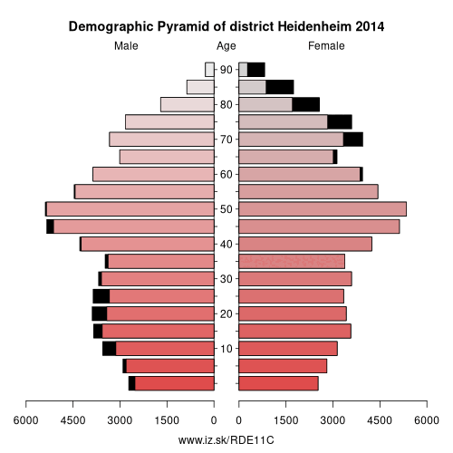
Demographics
| Indicator | Period | Value |
|---|---|---|
| Demographics | ||
| number of inhabitants | 2025 | 135 235 |
| population density | 2024 | 215.7 |
| old-age dependency ratio | 2025 | 36.4 |
Other: Stuttgart Government Region, Heilbronn, Main-Tauber-Kreis, Esslingen, Böblingen district, Göppingen, district Heidenheim, Rems-Murr, Ludwigsburg District, Landkreis Schwäbisch Hall, Stuttgart, Heilbronn, Hohenlohe, Ostalbkreis
Neighbours: Alb-Donau-Kreis, Günzburg, Landkreis Dillingen an der Donau, Donau-Ries, Göppingen, Ostalbkreis
Suggested citation: Michal Páleník: Europe and its regions in numbers - district Heidenheim – DE11C, IZ Bratislava, retrieved from: https://www.iz.sk/PDE11C, ISBN: 978-80-970204-9-1, DOI:10.5281/zenodo.10200164
https://www.iz.sk/en/projects/eu-regions/DE11C
 Share
Share Facebook
 Twitter
 News
News