Weilheim-Schongau – DE21N
EU regions: Germany > Bavaria > Upper Bavaria > Weilheim-Schongau
| Indicator | Period | Value |
|---|---|---|
| Gross domestic product | ||
| GDP per capita in PPS of EU average | 2023 | 115 |
Weilheim-Schongau slovensky: DE21N
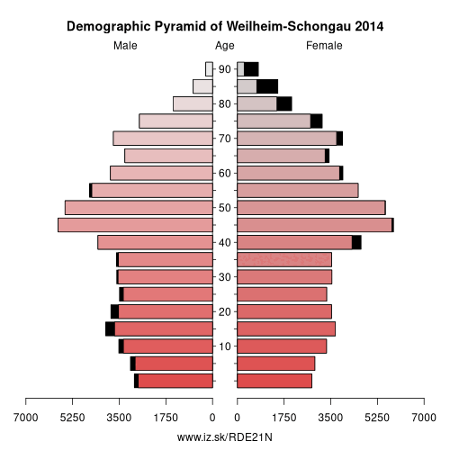
Demographics
| Indicator | Period | Value |
|---|---|---|
| Demographics | ||
| number of inhabitants | 2025 | 138 957 |
| population density | 2024 | 144.9 |
| old-age dependency ratio | 2025 | 37.2 |
From Wikipedia : Weilheim-Schongau is a Landkreis (district) in the south of Bavaria, Germany. Neighboring districts are (from the north clockwise) Landsberg, Starnberg, Bad Tölz-Wolfratshausen, Garmisch-Partenkirchen and Ostallgäu.
Geography
The district is located in the northern foothills of the Alps. The main rivers of the district are the Lech and the Ammer. The Ammersee and the Starnberger See are at the northern boundary of the district.
History
The district was formed in 1972 by merging the former districts Weilheim and Schongau, and one municipality from the former district Marktoberdorf.
Other: Upper Bavaria, Rosenheim, Starnberg, Ingolstadt, Munich, Landkreis Landsberg am Lech, Landkreis Mühldorf am Inn, Munich, Neuburg-Schrobenhausen, Traunstein, Weilheim-Schongau, Altötting county, Berchtesgadener Land, Dachau, Eichstätt district, Erding, Fürstenfeldbruck, Ebersberg, Freising, Garmisch-Partenkirchen, Bad Tölz-Wolfratshausen, Miesbach, Landkreis Pfaffenhofen an der Ilm, Rosenheim
Neighbours: Ostallgäu, Starnberg, Landkreis Landsberg am Lech, Garmisch-Partenkirchen, Bad Tölz-Wolfratshausen
Suggested citation: Michal Páleník: Europe and its regions in numbers - Weilheim-Schongau – DE21N, IZ Bratislava, retrieved from: https://www.iz.sk/PDE21N, ISBN: 978-80-970204-9-1, DOI:10.5281/zenodo.10200164
 Share
Share Facebook
 Twitter
 News
News