Landkreis Landsberg am Lech – DE21E
EU regions: Germany > Bavaria > Upper Bavaria > Landkreis Landsberg am Lech
| Indicator | Period | Value |
|---|---|---|
| Gross domestic product | ||
| GDP per capita in PPS of EU average | 2023 | 105 |
Landkreis Landsberg am Lech slovensky: DE21E
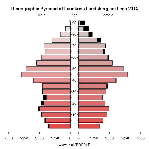
Demographics
| Indicator | Period | Value |
|---|---|---|
| Demographics | ||
| number of inhabitants | 2025 | 122 107 |
| population density | 2024 | 162.3 |
| old-age dependency ratio | 2025 | 34.6 |
Other: Upper Bavaria, Rosenheim, Starnberg, Ingolstadt, Munich, Landkreis Landsberg am Lech, Landkreis Mühldorf am Inn, Munich, Neuburg-Schrobenhausen, Traunstein, Weilheim-Schongau, Altötting county, Berchtesgadener Land, Dachau, Eichstätt district, Erding, Fürstenfeldbruck, Ebersberg, Freising, Garmisch-Partenkirchen, Bad Tölz-Wolfratshausen, Miesbach, Landkreis Pfaffenhofen an der Ilm, Rosenheim
Neighbours: Ostallgäu, Starnberg, Fürstenfeldbruck, Augsburg, Weilheim-Schongau, Aichach-Friedberg
Suggested citation: Michal Páleník: Europe and its regions in numbers - Landkreis Landsberg am Lech – DE21E, IZ Bratislava, retrieved from: https://www.iz.sk/PDE21E, ISBN: 978-80-970204-9-1, DOI:10.5281/zenodo.10200164
 Share
Share Facebook
 Twitter
 News
News