Seine-Saint-Denis – FR106
EU regions: France > Île-de-France > Île-de-France > Seine-Saint-Denis
| Indicator | Period | Value |
|---|---|---|
| Gross domestic product | ||
| GDP per capita in PPS of EU average | 2024 | 111 |
Seine-Saint-Denis slovensky: FR106
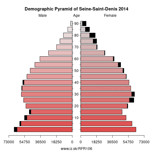
Demographics
| Indicator | Period | Value |
|---|---|---|
| Demographics | ||
| number of inhabitants | 2025 | 1 731 789 |
| population density | 2024 | 7309.4 |
| old-age dependency ratio | 2025 | 20.4 |
From Wikipedia : Seine-Saint-Denis (French pronunciation: [sɛn sɛ̃ d(ə)ni]) is a French department located in the Île-de-France region. Locally, it is often referred to colloquially as quatre-vingt treize or neuf trois (i.e. „ninety-three" or „nine three"), after its official administrative number, 93.
The learned and rarely used demonym for the inhabitants is Séquano-Dionysiens; more common is Dionysiens.
Geography
Seine-Saint-Denis is located to the northeast of Paris. It has a surface area of only 236 km², making it one of the smallest departments in France. Seine-Saint-Denis and two other small departments, Hauts-de-Seine and Val-de-Marne, form a ring around Paris, known as the Petite Couronne ("little crown"). Since 1 January 2016, together with Paris, they form the area of Greater Paris.
Administration
Seine-Saint-Denis is made up of three departmental arrondissements and 40 communes:
History
Seine-Saint-Denis was created in January 1968, through the implementation of a law passed in July 1964. It was formed from the part of the (hitherto larger) Seine department to the north and north-east of the Paris ring road (and the line of the old city walls), together with a small slice taken from Seine-et-Oise.Other: Île-de-France, Seine-et-Marne, Seine-Saint-Denis, Val-d'Oise, Paris, Yvelines, Hauts-de-Seine, Essonne, Val-de-Marne
Neighbours: Val-d'Oise, Hauts-de-Seine, Val-de-Marne, Seine-et-Marne, Paris
Suggested citation: Michal Páleník: Europe and its regions in numbers - Seine-Saint-Denis – FR106, IZ Bratislava, retrieved from: https://www.iz.sk/PFR106, ISBN: 978-80-970204-9-1, DOI:10.5281/zenodo.10200164
 Share
Share Facebook
 Twitter
 News
News