Île-de-France – FR10
EU regions: France > Île-de-France > Île-de-France
| Indicator | Period | Value |
|---|---|---|
| Life long learning | ||
| life long learning participation | 2025 | 18 |
| Part time jobs and flexible employment | ||
| percentage of part time workers | 2025 | 13.89 |
| percentage of part time workers, men | 2025 | 8.01 |
| percentage of part time workers, women | 2025 | 19.96 |
| Gender differences | ||
| gender gap in employment rate | 2025 | 92.96 |
| gender gap in unemployment rate | 2025 | 98.88 |
| Graduates and young people | ||
| unemployment rate of youth with elementary education | 2025 | 39.4 |
| NEET | 2025 | 10.4 |
| Gross domestic product | ||
| GDP per capita in PPS of EU average | 2024 | 160 |
| Employment | ||
| employment rate | 2025 | 69.8 |
Île-de-France slovensky: FR10
Subregions: Paris, Seine-et-Marne, Yvelines, Essonne, Hauts-de-Seine, Seine-Saint-Denis, Val-de-Marne, Val-d'Oise
Unemployment
| Indicator | Period | Value |
|---|---|---|
| Unemployment | ||
| unemployment rate | 2025 | 8.9 |
| youth unemployment rate | 2025 | 21.2 |
| Long term unemployment | ||
| long term unemployment | 2025 | 2.4 |
| share of long term unemployed | 2025 | 26.7 |
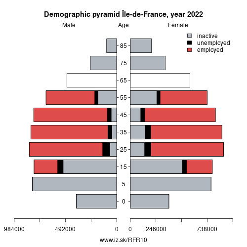
Demographics
| Indicator | Period | Value |
|---|---|---|
| Demographics | ||
| number of inhabitants | 2025 | 12 549 288 |
| population density | 2024 | 1048.2 |
| old-age dependency ratio | 2025 | 24.9 |
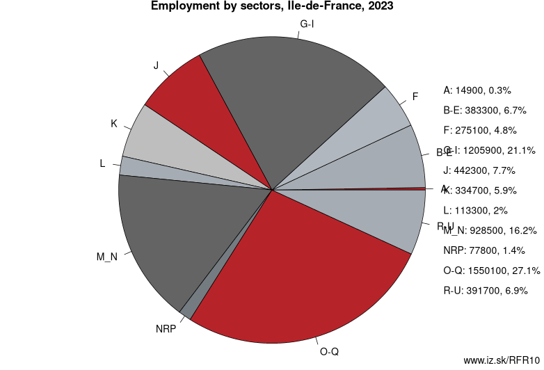
Employment by sectors, Île-de-France
| NACE r2 | % | NACE r2 | % | ||
|---|---|---|---|---|---|
| A | 15.4 | 0% | B-E | 424.3 | 7% |
| F | 297.8 | 5% | G-I | 1331.1 | 23% |
| J | 480.4 | 8% | K | 310.5 | 5% |
| L | 116.8 | 2% | M_N | 886.1 | 15% |
| NRP | 89.1 | 2% | O-Q | 1456.2 | 25% |
| R-U | 359.9 | 6% | TOTAL | 5767.6 | 100% |
Data for the period year 2025. Source of the data is Eurostat, table [lfst_r_lfe2en2].
From Wikipedia :
Île-de-France (; French: [il də fʁɑ̃s] (listen), literally „Island of France") is the most populous of the 18 regions of France. It is located in the north-central part of the country and often called the région parisienne ("Paris Region") due to containing the city of Paris. Île-de-France is densely populated and economically important: it covers only 12,012 square kilometres (4,638 square miles), about 2 % of France's territory, but has an official estimated population of 12,213,364 (18.2 % of the population of France) and accounts for nearly 30 % of the French Gross Domestic Product (GDP).The region is made up of eight administrative departments: Paris, Essonne, Hauts-de-Seine, Seine-Saint-Denis, Seine-et-Marne, Val-de-Marne, Val-d'Oise and Yvelines. It was created as the „District of the Paris Region" in 1961 and renamed in 1976 after the historic province of Île-de-France, when its status was aligned with the other French administrative regions created in 1972. Residents are sometimes referred to as Franciliens, an administrative word created in the 1980s.
The GDP of the region in 2016 was €681 billion (or $850 billion USD at market exchange rates). It has the highest per-capita GDP among regions in France and the third-highest of regions in the European Union. In 2018, almost all of the twenty-eight French companies listed in the Fortune Global 500 had their headquarters in the Paris Region.
Besides the landmarks of Paris, the region has many important historic sites, including the Palace of Versailles and the Palace of Fontainebleau, as well as the most-visited tourist attraction in France, Disneyland Paris.
The poverty rate in Ile-de-France was 15.9 % in 2015, compared with 12.3 % in 2006.
Other: Île-de-France, Île-de-France
Neighbours: Champagne-Ardenne, Upper Normandy, Burgundy, Centre-Val de Loire, Picardy
Subregions: Paris, Seine-et-Marne, Yvelines, Essonne, Hauts-de-Seine, Seine-Saint-Denis, Val-de-Marne, Val-d'Oise
Suggested citation: Michal Páleník: Europe and its regions in numbers - Île-de-France – FR10, IZ Bratislava, retrieved from: https://www.iz.sk/PFR10, ISBN: 978-80-970204-9-1, DOI:10.5281/zenodo.10200164
Similar articles
Navigation:
- Short news
- Local Administrative Units data of Visegrad countries open data
- Projects and activities
- European regions
- Random region: Austria, Western Austria, Tyrol, Innsbruck
 Share
Share Facebook
 Twitter
 News
News