Champagne-Ardenne – FRF2
EU regions: France > Grand Est > Champagne-Ardenne
| Indicator | Period | Value |
|---|---|---|
| Life long learning | ||
| life long learning participation | 2025 | 13.6 |
| Part time jobs and flexible employment | ||
| percentage of part time workers | 2025 | 18.68 |
| percentage of part time workers, men | 2025 | 8.08 |
| percentage of part time workers, women | 2025 | 30.25 |
| Gender differences | ||
| gender gap in employment rate | 2025 | 90.24 |
| gender gap in unemployment rate | 2025 | 107.35 |
| Graduates and young people | ||
| unemployment rate of youth with elementary education | 2025 | 31 |
| NEET | 2025 | 13.9 |
| Gross domestic product | ||
| GDP per capita in PPS of EU average | 2024 | 87 |
| Employment | ||
| employment rate | 2025 | 67.3 |
Champagne-Ardenne slovensky: FRF2
Subregions: Ardennes, Aube, Marne, Haute-Marne
Unemployment
| Indicator | Period | Value |
|---|---|---|
| Unemployment | ||
| unemployment rate | 2025 | 7.1 |
| youth unemployment rate | 2025 | 18.6 |
| Long term unemployment | ||
| long term unemployment | 2025 | 1.6 |
| share of long term unemployed | 2025 | 23 |
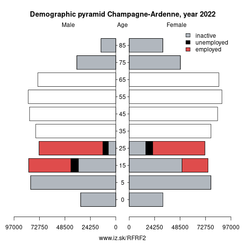
Demographics
| Indicator | Period | Value |
|---|---|---|
| Demographics | ||
| number of inhabitants | 2025 | 1 296 360 |
| population density | 2024 | 50.9 |
| old-age dependency ratio | 2025 | 39 |
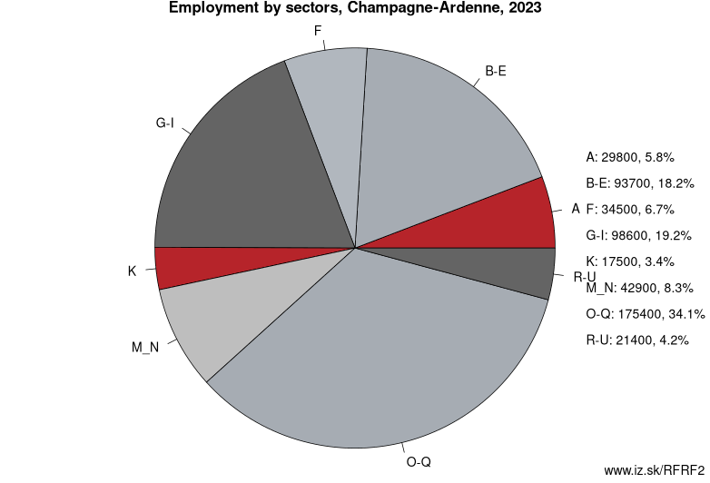
Employment by sectors, Champagne-Ardenne
| NACE r2 | % | NACE r2 | % | ||
|---|---|---|---|---|---|
| A | 27 | 5% | B-E | 96.8 | 18% |
| F | 33.6 | 6% | G-I | 106.1 | 20% |
| J | 5 | 1% | K | 11.5 | 2% |
| M_N | 41.6 | 8% | NRP | 7.4 | 1% |
| O-Q | 170.3 | 32% | R-U | 24.5 | 5% |
| TOTAL | 526.7 | 100% |
Data for the period year 2025. Source of the data is Eurostat, table [lfst_r_lfe2en2].
From Wikipedia :
Champagne-Ardenne (French pronunciation: [ʃɑ̃paɲaʁdɛn]) is a former administrative region of France, located in the northeast of the country, bordering Belgium. Mostly corresponding to the historic province of Champagne, the region is known for its sparkling white wine of the same name.The administrative region was formed in 1956, consisting of the four departments Aube, Ardennes, Haute-Marne, and Marne. On 1 January 2016, it merged with the neighboring regions of Alsace and Lorraine to form the new region Grand Est, thereby ceasing to exist as an independent entity.
Its rivers, most of which flow west, include the Seine, the Marne, and the Aisne. The Meuse flows north.
Transportation
Highways
- A4 connecting Paris and Strasbourg and serving the Reims metropolitan area
- A5 connecting Paris and Dijon and serving Troyes and Chaumont
- A26 connecting Calais and Troyes and serving Reims and Châlons-en-Champagne
- A34 connecting Reims and the Belgian border and serving Charleville-Mézières
Rail
The rail network includes the Paris–Strasbourg line, which follows the Marne Valley and serves Épernay, Châlons-en-Champagne, and Vitry-le-François. The LGV Est TGV line also connecting Paris and Strasbourg opened in 2007 and serves Reims with a train station in the commune of Bezannes.
Water
The region's canals include the Canal latéral à la Marne and Marne-Rhine Canal, the latter connecting to the Marne at Vitry-le-François. These are petit gabarit canals.
Air
The Vatry International Airport, primarily dedicated to air freight, has a runway 3,650 m (11,980 ft) long.
Other: Grand Est, Champagne-Ardenne, Lorraine, Vertonne
Neighbours: Franche-Comté, Province of Namur, Lorraine, Burgundy, Île-de-France, Luxembourg, Picardy, Hainaut
Subregions: Ardennes, Aube, Marne, Haute-Marne
Suggested citation: Michal Páleník: Europe and its regions in numbers - Champagne-Ardenne – FRF2, IZ Bratislava, retrieved from: https://www.iz.sk/PFRF2, ISBN: 978-80-970204-9-1, DOI:10.5281/zenodo.10200164
 Share
Share Facebook
 Twitter
 News
News