Franche-Comté – FRC2
EU regions: France > Bourgogne-Franche-Comté > Franche-Comté
| Indicator | Period | Value |
|---|---|---|
| Life long learning | ||
| life long learning participation | 2025 | 14.7 |
| Part time jobs and flexible employment | ||
| percentage of part time workers | 2025 | 24.32 |
| percentage of part time workers, men | 2025 | 11.91 |
| percentage of part time workers, women | 2025 | 37.86 |
| Gender differences | ||
| gender gap in employment rate | 2025 | 91.75 |
| gender gap in unemployment rate | 2025 | 117.33 |
| Graduates and young people | ||
| unemployment rate of youth with elementary education | 2017 | 40.1 |
| NEET | 2025 | 13 |
| Gross domestic product | ||
| GDP per capita in PPS of EU average | 2024 | 74 |
| Employment | ||
| employment rate | 2025 | 67.4 |
Franche-Comté slovensky: FRC2
Subregions: Doubs, Jura, Haute-Saône, Territoire de Belfort
Unemployment
| Indicator | Period | Value |
|---|---|---|
| Unemployment | ||
| unemployment rate | 2025 | 8.3 |
| youth unemployment rate | 2025 | 19.5 |
| Long term unemployment | ||
| long term unemployment | 2025 | 1.7 |
| share of long term unemployed | 2025 | 20.4 |
Demographics
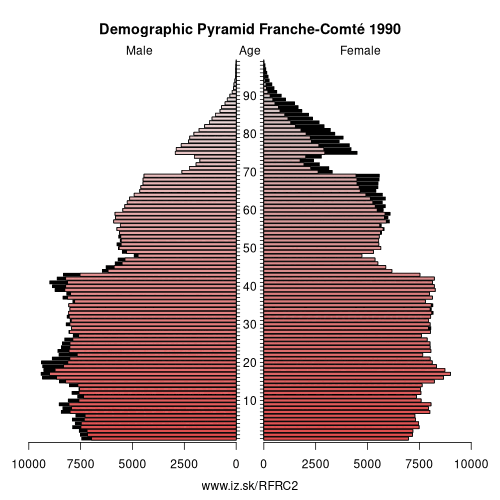
| Indicator | Period | Value |
|---|---|---|
| Demographics | ||
| number of inhabitants | 2025 | 1 175 558 |
| population density | 2024 | 72.6 |
| old-age dependency ratio | 2025 | 38.5 |
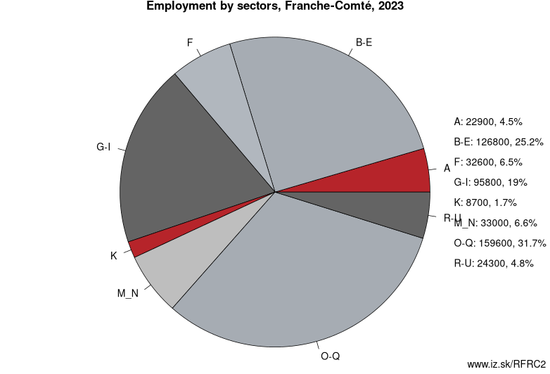
Employment by sectors, Franche-Comté
| NACE r2 | % | NACE r2 | % | ||
|---|---|---|---|---|---|
| A | 20.7 | 4% | B-E | 117.5 | 25% |
| F | 23.9 | 5% | G-I | 87.7 | 18% |
| K | 9.9 | 2% | L | 10.6 | 2% |
| M_N | 35.9 | 8% | NRP | 8.2 | 2% |
| O-Q | 134 | 28% | R-U | 23.8 | 5% |
| TOTAL | 477.1 | 100% |
Data for the period year 2025. Source of the data is Eurostat, table [lfst_r_lfe2en2].
From Wikipedia : Torgau-Oschatz is a former district (Kreis) in the Free State of Saxony, Germany. It was bounded by (from the north and clockwise) the district Wittenberg in Saxony-Anhalt, the district Elbe-Elster in Brandenburg, and the districts Riesa-Großenhain, Döbeln, Muldentalkreis and Delitzsch.
History
The district was created in 1994 by merging the two previous districts Oschatz and Torgau, and 6 municipalities from the former district Eilenburg. In August 2008, as a part of the district reform in Saxony, the districts of Delitzsch and Torgau-Oschatz were merged into the new district Nordsachsen.
Geography
The main river in the district is the Elbe, which meanders through water meadows. The landscape is dominated by three heath areas, the Dahlener Heide (150 km²) in the south, the Düben Heath (110 km²) in the northwest, and partially the Annaburger Heide in the east.
Coat of arms
Towns and municipalities
External links
- Official website (German)
Other: Bourgogne-Franche-Comté, Burgundy, Franche-Comté
Neighbours: Lake Geneva region, Espace Mittelland, Lorraine, Champagne-Ardenne, Vertonne, Burgundy, Rhône-Alpes
Subregions: Doubs, Jura, Haute-Saône, Territoire de Belfort
Suggested citation: Michal Páleník: Europe and its regions in numbers - Franche-Comté – FRC2, IZ Bratislava, retrieved from: https://www.iz.sk/PFRC2, ISBN: 978-80-970204-9-1, DOI:10.5281/zenodo.10200164
 Share
Share Facebook
 Twitter
 News
News