Rhein-Neckar – DE128
EU regions: Germany > Baden-Württemberg > Karlsruhe Government Region > Rhein-Neckar
| Indicator | Period | Value |
|---|---|---|
| Gross domestic product | ||
| GDP per capita in PPS of EU average | 2023 | 107 |
Rhein-Neckar slovensky: DE128
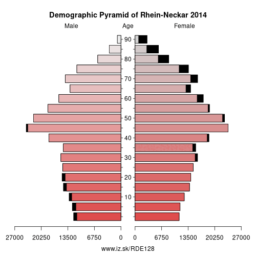
Demographics
| Indicator | Period | Value |
|---|---|---|
| Demographics | ||
| number of inhabitants | 2025 | 558 561 |
| population density | 2024 | 529.6 |
| old-age dependency ratio | 2025 | 36.6 |
From Wikipedia :
- This article is about the German district Rhein-Neckar-Kreis. See also the greater Rhine Neckar area in Germany.
History
The district was created in 1973 by merging the previous districts of Heidelberg, Mannheim and a big part of Sinsheim.
Geography
It is named after the two main rivers which flow through the district, the Rhine and Neckar. The highest elevation is the Stiefelhöhe, near Heiligkreuzsteinach, with 583 m in the Odenwald mountains, the lowest elevation with 92 m is near Ilvesheim in the Neckar valley.
Government
The district is governed by a district assembly (Kreistag) and a district executive (Landrat). The eligible voters of the district elect the Kreistag every 5 years. This body in turn elects the Landrat every 8 years.
Other: Karlsruhe Government Region, Karlsruhe, Landkreis Karlsruhe, Heidelberg, Rhein-Neckar, Baden-Baden, Enz District, Rastatt district, Freudenstadt, Calw District, Mannheim, Neckar-Odenwald, Pforzheim
Neighbours: Odenwald, Rhein-Pfalz, Landkreis Karlsruhe, Heilbronn, Mannheim, Landkreis Bergstraße, Speyer, Neckar-Odenwald, Heidelberg
Suggested citation: Michal Páleník: Europe and its regions in numbers - Rhein-Neckar – DE128, IZ Bratislava, retrieved from: https://www.iz.sk/PDE128, ISBN: 978-80-970204-9-1, DOI:10.5281/zenodo.10200164
 Share
Share Facebook
 Twitter
 News
News