Odenwald – DE71B
EU regions: Germany > Hesse > Darmstadt Government Region > Odenwald
| Indicator | Period | Value |
|---|---|---|
| Gross domestic product | ||
| GDP per capita in PPS of EU average | 2023 | 75 |
Odenwald slovensky: DE71B
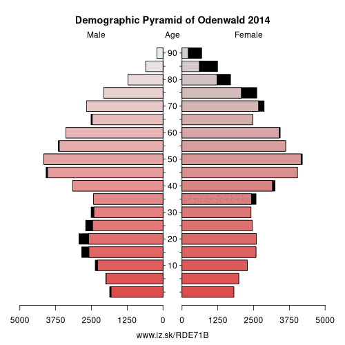
Demographics
| Indicator | Period | Value |
|---|---|---|
| Demographics | ||
| number of inhabitants | 2025 | 93 846 |
| population density | 2024 | 150.7 |
| old-age dependency ratio | 2025 | 42.3 |
From Wikipedia : The Odenwaldkreis is a Kreis (district) in the south of Hesse, Germany. Neighboring districts are Darmstadt-Dieburg, Miltenberg, Neckar-Odenwald-Kreis, Rhein-Neckar-Kreis and Kreis Bergstraße. Odenwaldkreis belongs to the Rhine Neckar Area.
History
In 1822 the district was created under the name Erbach, subdivided into two Bezirke Breuberg and Erbach. The last of several modifications of the district was in 1972, when some municipalities from the Dieburg and Bergstraße district were added to the district. In 1972 the district also changed its name.
Dietrich Kühler, in March 2015 Frank Matiaske (SPD) was voted as the successor of Dietrich Kühler and would be the chief from August 2015.
Geography
As the name of the district already suggests it is located in the Odenwald mountains.
Other: Darmstadt Government Region, Darmstadt-Dieburg, Hochtaunuskreis, Main-Kinzig-Kreis, Odenwald, Offenbach, Darmstadt, Wiesbaden, Groß-Gerau, Main-Taunus-Kreis, Landkreis Bergstraße, Rheingau-Taunus-Kreis, Frankfurt, Offenbach am Main, Wetteraukreis
Neighbours: Rhein-Neckar, Landkreis Bergstraße, Miltenberg, Darmstadt-Dieburg, Neckar-Odenwald
Suggested citation: Michal Páleník: Europe and its regions in numbers - Odenwald – DE71B, IZ Bratislava, retrieved from: https://www.iz.sk/PDE71B, ISBN: 978-80-970204-9-1, DOI:10.5281/zenodo.10200164
 Share
Share Facebook
 Twitter
 News
News