Darmstadt-Dieburg – DE716
EU regions: Germany > Hesse > Darmstadt Government Region > Darmstadt-Dieburg
| Indicator | Period | Value |
|---|---|---|
| Gross domestic product | ||
| GDP per capita in PPS of EU average | 2023 | 78 |
Darmstadt-Dieburg slovensky: DE716
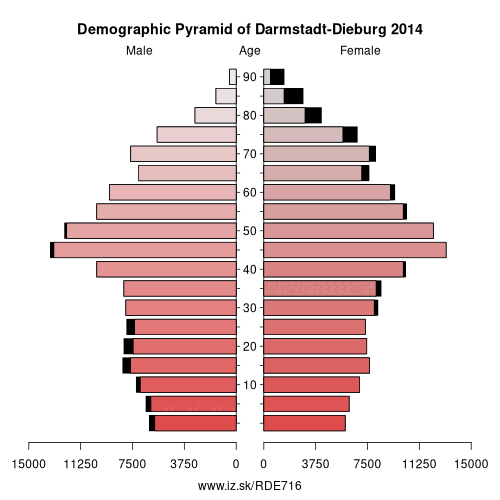
Demographics
| Indicator | Period | Value |
|---|---|---|
| Demographics | ||
| number of inhabitants | 2025 | 302 021 |
| population density | 2024 | 459.2 |
| old-age dependency ratio | 2025 | 35.4 |
From Wikipedia : Darmstadt-Dieburg is a Kreis (district) in the south of Hesse, Germany. Neighboring districts are Offenbach, Aschaffenburg, Miltenberg, Odenwaldkreis, Bergstraße, Groß-Gerau, and the district-free city of Darmstadt, which it surrounds.
History
The district was created in 1975 by merging the previous districts of Darmstadt and Dieburg. In 1963 the district was twinned with the district of North East Derbyshire, England, in 1990 with the district Zwickauer Land in Saxony, Germany, and in 1995 with the Mladá Boleslav region in the Czech Republic.
Geography
The district is located in the Odenwald mountains. Most famous in the district is the Messel Pit, where many fossils in the oil shale of a Tertiary lake were found. The site is listed in the UNESCO world heritage list since 1995.
Other: Darmstadt Government Region, Darmstadt-Dieburg, Hochtaunuskreis, Main-Kinzig-Kreis, Odenwald, Offenbach, Darmstadt, Wiesbaden, Groß-Gerau, Main-Taunus-Kreis, Landkreis Bergstraße, Rheingau-Taunus-Kreis, Frankfurt, Offenbach am Main, Wetteraukreis
Neighbours: Offenbach, Landkreis Bergstraße, Miltenberg, Aschaffenburg district, Groß-Gerau, Darmstadt, Odenwald
Suggested citation: Michal Páleník: Europe and its regions in numbers - Darmstadt-Dieburg – DE716, IZ Bratislava, retrieved from: https://www.iz.sk/PDE716, ISBN: 978-80-970204-9-1, DOI:10.5281/zenodo.10200164
 Share
Share Facebook
 Twitter
 News
News