Aschaffenburg district – DE264
EU regions: Germany > Bavaria > Lower Franconia > Aschaffenburg district
| Indicator | Period | Value |
|---|---|---|
| Gross domestic product | ||
| GDP per capita in PPS of EU average | 2023 | 105 |
Aschaffenburg district slovensky: DE264
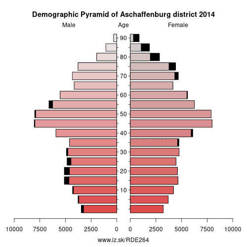
Demographics
| Indicator | Period | Value |
|---|---|---|
| Demographics | ||
| number of inhabitants | 2025 | 170 945 |
| population density | 2024 | 245.9 |
| old-age dependency ratio | 2025 | 37.9 |
Other: Lower Franconia, Schweinfurt, Bad Kissingen district, Main-Spessart, Aschaffenburg district, Rhön-Grabfeld, Würzburg, Würzburg, Kitzingen, Miltenberg, Haßberge, Aschaffenburg, Schweinfurt
Neighbours: Offenbach, Main-Spessart, Miltenberg, Main-Kinzig-Kreis, Darmstadt-Dieburg, Aschaffenburg
Suggested citation: Michal Páleník: Europe and its regions in numbers - Aschaffenburg district – DE264, IZ Bratislava, retrieved from: https://www.iz.sk/PDE264, ISBN: 978-80-970204-9-1, DOI:10.5281/zenodo.10200164
https://www.iz.sk/en/projects/eu-regions/DE264
 Share
Share Facebook
 Twitter
 News
News