Hochtaunuskreis – DE718
EU regions: Germany > Hesse > Darmstadt Government Region > Hochtaunuskreis
| Indicator | Period | Value |
|---|---|---|
| Gross domestic product | ||
| GDP per capita in PPS of EU average | 2023 | 169 |
Hochtaunuskreis slovensky: DE718
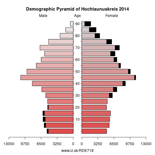
Demographics
| Indicator | Period | Value |
|---|---|---|
| Demographics | ||
| number of inhabitants | 2025 | 241 664 |
| population density | 2024 | 500.3 |
| old-age dependency ratio | 2025 | 37.8 |
From Wikipedia : The Hochtaunuskreis is a Kreis (district) in the middle of Hesse, Germany and is part of the Frankfurt/Rhine-Main Metropolitan Region. Neighbouring districts are Lahn-Dill, Wetteraukreis, district-free Frankfurt, Main-Taunus, Rheingau-Taunus, Limburg-Weilburg.
The Hochtaunuskreis and the Landkreis Starnberg regularly compete for the title of the wealthiest district in Germany.
History
The district was created in 1972 when the previous districts Obertaunus and Usingen were merged.
Geography
Geographically it covers the Taunus mountains. The highest elevation of the Taunus, the 881 meter high Großer Feldberg, is in the district. Lowest elevation of the district with 130 m is the village Ober Erlenbach. The wealthy towns in the district's densely populated southern part belong to the Frankfurt urban area.
Other: Darmstadt Government Region, Darmstadt-Dieburg, Hochtaunuskreis, Main-Kinzig-Kreis, Odenwald, Offenbach, Darmstadt, Wiesbaden, Groß-Gerau, Main-Taunus-Kreis, Landkreis Bergstraße, Rheingau-Taunus-Kreis, Frankfurt, Offenbach am Main, Wetteraukreis
Neighbours: Wetteraukreis, Limburg-Weilburg, Lahn-Dill-Kreis, Main-Taunus-Kreis, Rheingau-Taunus-Kreis, Frankfurt
Suggested citation: Michal Páleník: Europe and its regions in numbers - Hochtaunuskreis – DE718, IZ Bratislava, retrieved from: https://www.iz.sk/PDE718, ISBN: 978-80-970204-9-1, DOI:10.5281/zenodo.10200164
 Share
Share Facebook
 Twitter
 News
News