Neckar-Odenwald – DE127
EU regions: Germany > Baden-Württemberg > Karlsruhe Government Region > Neckar-Odenwald
| Indicator | Period | Value |
|---|---|---|
| Gross domestic product | ||
| GDP per capita in PPS of EU average | 2023 | 86 |
Neckar-Odenwald slovensky: DE127
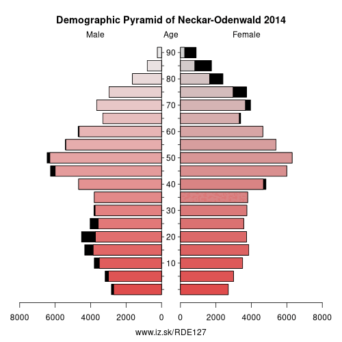
Demographics
| Indicator | Period | Value |
|---|---|---|
| Demographics | ||
| number of inhabitants | 2025 | 145 263 |
| population density | 2024 | 129.5 |
| old-age dependency ratio | 2025 | 38.3 |
From Wikipedia : Neckar-Odenwald-Kreis is a Landkreis (district) in the north of Baden-Württemberg, Germany. Neighboring districts are (from east clockwise) Main-Tauber-Kreis, Hohenlohe-Kreis, Heilbronn, Rhein-Neckar-Kreis, Odenwaldkreis (Hesse) and Landkreis Miltenberg (Bavaria). The Neckar-Odenwald-Kreis is part of the Rhine Neckar Area.
History
The district was created in 1973 by merging the previous districts Buchen and Mosbach. At first it was named Odenwaldkreis, however to avoid confusion with the neighboring district in Hesse with the same name it was renamed in 1974 to be Neckar-Odenwald-Kreis.
Geography
As the name already suggests the district is located in the Odenwald mountains, with the highest elevation at the Katzenbuckel (626 m) near Waldbrunn in the west of the district. The main river of the district is the Neckar.
Other: Karlsruhe Government Region, Karlsruhe, Landkreis Karlsruhe, Heidelberg, Rhein-Neckar, Baden-Baden, Enz District, Rastatt district, Freudenstadt, Calw District, Mannheim, Neckar-Odenwald, Pforzheim
Neighbours: Rhein-Neckar, Main-Tauber-Kreis, Miltenberg, Hohenlohe, Odenwald, Heilbronn
Suggested citation: Michal Páleník: Europe and its regions in numbers - Neckar-Odenwald – DE127, IZ Bratislava, retrieved from: https://www.iz.sk/PDE127, ISBN: 978-80-970204-9-1, DOI:10.5281/zenodo.10200164
 Share
Share Facebook
 Twitter
 News
News