Passau – DE228
EU regions: Germany > Bavaria > Lower Bavaria > Passau
| Indicator | Period | Value |
|---|---|---|
| Gross domestic product | ||
| GDP per capita in PPS of EU average | 2023 | 90 |
Passau slovensky: DE228
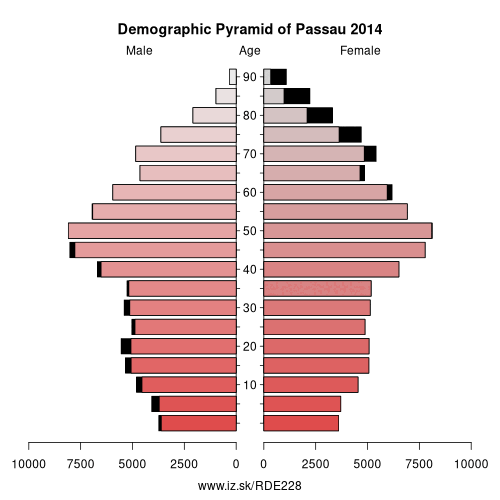
Demographics
| Indicator | Period | Value |
|---|---|---|
| Demographics | ||
| number of inhabitants | 2025 | 194 699 |
| population density | 2024 | 128.2 |
| old-age dependency ratio | 2025 | 40 |
Other: Lower Bavaria, Rottal-Inn, Deggendorf, Landshut, Regen, Dingolfing-Landau, Straubing, Kelheim, Passau, Freyung-Grafenau, Straubing-Bogen, Passau, Landshut
Neighbours: Innviertel, Freyung-Grafenau, Passau, Rottal-Inn, Mühlviertel, Deggendorf
Suggested citation: Michal Páleník: Europe and its regions in numbers - Passau – DE228, IZ Bratislava, retrieved from: https://www.iz.sk/PDE228, ISBN: 978-80-970204-9-1, DOI:10.5281/zenodo.10200164
https://www.iz.sk/en/projects/eu-regions/DE228
 Share
Share Facebook
 Twitter
 News
News