Donnersbergkreis – DEB3D
EU regions: Germany > Rhineland-Palatinate > Rheinhessen-Pfalz > Donnersbergkreis
| Indicator | Period | Value |
|---|---|---|
| Gross domestic product | ||
| GDP per capita in PPS of EU average | 2023 | 77 |
Donnersbergkreis slovensky: DEB3D
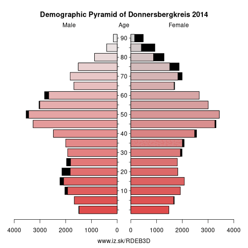
Demographics
| Indicator | Period | Value |
|---|---|---|
| Demographics | ||
| number of inhabitants | 2025 | 74 783 |
| population density | 2024 | 115.9 |
| old-age dependency ratio | 2025 | 39.7 |
From Wikipedia : The Donnersbergkreis is a district (Kreis) in the middle of Rhineland-Palatinate, Germany. Neighboring districts are Bad Kreuznach, Alzey-Worms, Bad Dürkheim, Kaiserslautern, Kusel.
History
The district was created in 1969 by merging the districts Kirchheimbolanden and Rockenhausen.
Geography
The district is located around the highest mountain of the Palatinate, the Donnersberg with 687 m above sea level.
Other: Rheinhessen-Pfalz, Landau in der Pfalz, Ludwigshafen, Mainz, Neustadt an der Weinstraße, Pirmasens, Worms, Zweibrücken, Bad Dürkheim, Donnersbergkreis, Germersheim, Kaiserslautern, Südliche Weinstraße, Speyer, Südwestpfalz, Kusel, Frankenthal, Rhein-Pfalz, Alzey-Worms district, Kaiserslautern, Mainz-Bingen district
Neighbours: Kaiserslautern, Bad Kreuznach, Kusel, Bad Dürkheim, Alzey-Worms district
Suggested citation: Michal Páleník: Europe and its regions in numbers - Donnersbergkreis – DEB3D, IZ Bratislava, retrieved from: https://www.iz.sk/PDEB3D, ISBN: 978-80-970204-9-1, DOI:10.5281/zenodo.10200164
 Share
Share Facebook
 Twitter
 News
News