Frankenthal – DEB31
EU regions: Germany > Rhineland-Palatinate > Rheinhessen-Pfalz > Frankenthal
| Indicator | Period | Value |
|---|---|---|
| Gross domestic product | ||
| GDP per capita in PPS of EU average | 2023 | 106 |
Frankenthal slovensky: DEB31
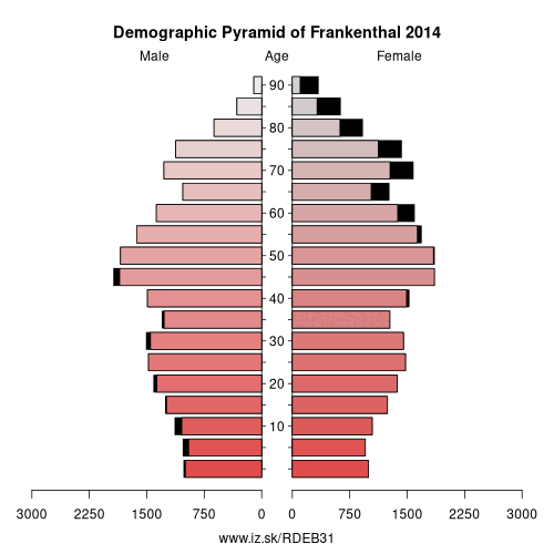
Demographics
| Indicator | Period | Value |
|---|---|---|
| Demographics | ||
| number of inhabitants | 2025 | 48 140 |
| population density | 2024 | 1119.2 |
| old-age dependency ratio | 2025 | 38.6 |
From Wikipedia : Frankenthal (Pfalz) is a town in southwestern Germany, in the state of Rhineland-Palatinate.
History
Frankenthal was first mentioned in 772. In 1119 an Augustinian monastery was built here, the ruins of which — known, after the founder, as the Erkenbertruine — still stand today in the town centre.
In the second half of the 16th century, people from Flanders, persecuted for their religious beliefs, settled in Frankenthal. They were industrious and artistic and brought economic prosperity to the town. Some of them were important carpet weavers, jewellers and artists whose Frankenthaler Malerschule ("Frankenthal school of painting") acquired some fame. In 1577 the settlement was raised to the status of a town by the Count Palatine Johann Casimir.
In 1600 Frankenthal was converted to a fortress. In 1621 it was besieged by the Spanish during the Thirty Years' War, and then successively occupied by troops of the opposing sides. Trade and industry were ruined and the town was not reconstructed until 1682.
Other: Rheinhessen-Pfalz, Landau in der Pfalz, Ludwigshafen, Mainz, Neustadt an der Weinstraße, Pirmasens, Worms, Zweibrücken, Bad Dürkheim, Donnersbergkreis, Kaiserslautern, Germersheim, Südliche Weinstraße, Speyer, Südwestpfalz, Kusel, Frankenthal, Rhein-Pfalz, Alzey-Worms district, Kaiserslautern, Mainz-Bingen district
Neighbours: Mannheim, Rhein-Pfalz, Ludwigshafen
Suggested citation: Michal Páleník: Europe and its regions in numbers - Frankenthal – DEB31, IZ Bratislava, retrieved from: https://www.iz.sk/PDEB31, ISBN: 978-80-970204-9-1, DOI:10.5281/zenodo.10200164
 Share
Share Facebook
 Twitter
 News
News