Rheinhessen-Pfalz – DEB3
EU regions: Germany > Rhineland-Palatinate > Rheinhessen-Pfalz

| Indicator | Period | Value |
|---|---|---|
| Life long learning | ||
| life long learning participation | 2025 | 10.1 |
| Part time jobs and flexible employment | ||
| percentage of part time workers | 2025 | 30.38 |
| percentage of part time workers, men | 2025 | 12.04 |
| percentage of part time workers, women | 2025 | 52 |
| Gender differences | ||
| gender gap in employment rate | 2025 | 89.06 |
| gender gap in unemployment rate | 2025 | 102.5 |
| Graduates and young people | ||
| unemployment rate of youth with elementary education | 2017 | 13.8 |
| NEET | 2025 | 9.2 |
| Gross domestic product | ||
| GDP per capita in PPS of EU average | 2024 | 107 |
| Employment | ||
| employment rate | 2025 | 77.9 |
| Social exclusion | ||
| people at risk of poverty or social exclusion | 2019 | 16.5 |
Rheinhessen-Pfalz slovensky: DEB3
Subregions: Frankenthal, Kaiserslautern, Landau in der Pfalz, Ludwigshafen, Mainz, Neustadt an der Weinstraße, Pirmasens, Speyer, Worms, Zweibrücken, Alzey-Worms district, Bad Dürkheim, Donnersbergkreis, Germersheim, Kaiserslautern, Kusel, Südliche Weinstraße, Rhein-Pfalz, Mainz-Bingen district, Südwestpfalz
Unemployment
| Indicator | Period | Value |
|---|---|---|
| Unemployment | ||
| unemployment rate | 2025 | 4.2 |
| youth unemployment rate | 2019 | 6.4 |
| Long term unemployment | ||
| long term unemployment | 2025 | 1.2 |
| share of long term unemployed | 2025 | 29.9 |
Demographics

| Indicator | Period | Value |
|---|---|---|
| Demographics | ||
| number of inhabitants | 2025 | 2 073 778 |
| population density | 2024 | 305 |
| old-age dependency ratio | 2025 | 36.2 |
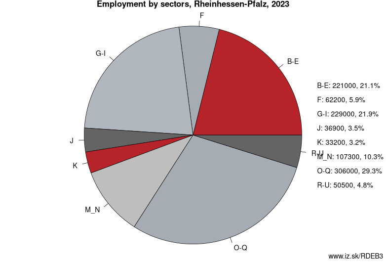
Employment by sectors, Rheinhessen-Pfalz
| NACE r2 | % | NACE r2 | % | ||
|---|---|---|---|---|---|
| A | 15.8 | 1% | B-E | 212.9 | 20% |
| F | 60.3 | 6% | G-I | 217.5 | 20% |
| J | 48.2 | 4% | K | 30 | 3% |
| M_N | 103 | 10% | O-Q | 320.3 | 30% |
| R-U | 55.2 | 5% | TOTAL | 1073.1 | 100% |
Data for the period year 2025. Source of the data is Eurostat, table [lfst_r_lfe2en2].
From Wikipedia : Rheinhessen-Pfalz (rarely anglicized as „Rhine-Hesse-Palatinate") was one of the three Regierungsbezirke of Rhineland-Palatinate, Germany, located in the south of the state. It was created in 1968 out of Regierungsbezirke Rheinhessen and Pfalz, which had themselves been created out of the left-bank territories of Bavaria and Hesse-Darmstadt before World War II.
Since 2000, the employees and assets of the Bezirksregierungen form the Aufsichts- und Dienstleistungsdirektion Trier (Supervisory and Service Directorate Trier) and the Struktur- und Genehmigungsdirektionen (Structural and Approval Directorates) Nord in Koblenz and Süd in Neustadt (Weinstraße). These administrations execute their authority over the whole state, e.g. the ADD Trier oversees all schools.
Other: Rhineland-Palatinate, Rheinhessen-Pfalz, Koblenz Government Region, Trier Government Region
Neighbours: Lorraine, Vertonne, Koblenz Government Region, Karlsruhe Government Region, Saarland, Darmstadt Government Region
Subregions: Frankenthal, Kaiserslautern, Landau in der Pfalz, Ludwigshafen, Mainz, Neustadt an der Weinstraße, Pirmasens, Speyer, Worms, Zweibrücken, Alzey-Worms district, Bad Dürkheim, Donnersbergkreis, Germersheim, Kaiserslautern, Kusel, Südliche Weinstraße, Rhein-Pfalz, Mainz-Bingen district, Südwestpfalz
Suggested citation: Michal Páleník: Europe and its regions in numbers - Rheinhessen-Pfalz – DEB3, IZ Bratislava, retrieved from: https://www.iz.sk/PDEB3, ISBN: 978-80-970204-9-1, DOI:10.5281/zenodo.10200164
 Share
Share Facebook
 Twitter
 News
News