Mansfeld-Südharz – DEE0A
EU regions: Germany > Saxony-Anhalt > Saxony-Anhalt > Mansfeld-Südharz
| Indicator | Period | Value |
|---|---|---|
| Gross domestic product | ||
| GDP per capita in PPS of EU average | 2023 | 66 |
Mansfeld-Südharz slovensky: DEE0A
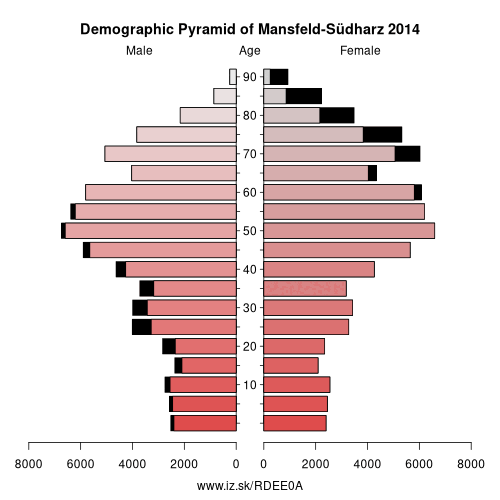
Demographics
| Indicator | Period | Value |
|---|---|---|
| Demographics | ||
| number of inhabitants | 2025 | 129 029 |
| population density | 2024 | 90.1 |
| old-age dependency ratio | 2025 | 56.9 |
From Wikipedia : Mansfeld-Südharz is a district in Saxony-Anhalt, Germany.
History
The district was established by merging the former districts of Sangerhausen and Mansfelder Land as part of the reform of 2007. In the German parliament, the Bundestag, the area forms part of the Mansfeld electoral district.
Other: Saxony-Anhalt, Magdeburg, Jerichower Land, Dessau-Roßlau, Harz District, Anhalt-Bitterfeld, Altmarkkreis Salzwedel, Salzlandkreis, Wittenberg, Saalekreis, Mansfeld-Südharz, Stendal District, Börde district, Halle (Saale), Burgenlandkreis
Neighbours: Saalekreis, Harz District, Kyffhäuserkreis, Nordhausen, Salzlandkreis
Suggested citation: Michal Páleník: Europe and its regions in numbers - Mansfeld-Südharz – DEE0A, IZ Bratislava, retrieved from: https://www.iz.sk/PDEE0A, ISBN: 978-80-970204-9-1, DOI:10.5281/zenodo.10200164
 Share
Share Facebook
 Twitter
 News
News