Stendal District – DEE0D
EU regions: Germany > Saxony-Anhalt > Saxony-Anhalt > Stendal District
| Indicator | Period | Value |
|---|---|---|
| Gross domestic product | ||
| GDP per capita in PPS of EU average | 2023 | 86 |
Stendal District slovensky: DEE0D
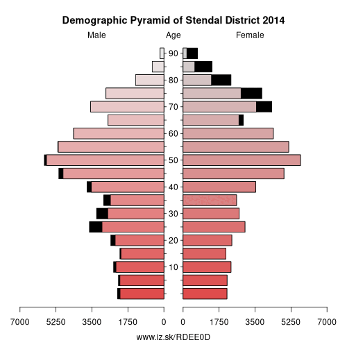
Demographics
| Indicator | Period | Value |
|---|---|---|
| Demographics | ||
| number of inhabitants | 2025 | 106 538 |
| population density | 2024 | 44.6 |
| old-age dependency ratio | 2025 | 48.7 |
Other: Saxony-Anhalt, Jerichower Land, Halle (Saale), Dessau-Roßlau, Harz District, Anhalt-Bitterfeld, Altmarkkreis Salzwedel, Salzlandkreis, Wittenberg, Saalekreis, Mansfeld-Südharz, Stendal District, Börde district, Magdeburg, Burgenlandkreis
Neighbours: Ostprignitz-Ruppin District, Altmarkkreis Salzwedel, Havelland District, Prignitz District, Lüchow-Dannenberg District, Börde district, Jerichower Land
Suggested citation: Michal Páleník: Europe and its regions in numbers - Stendal District – DEE0D, IZ Bratislava, retrieved from: https://www.iz.sk/PDEE0D, ISBN: 978-80-970204-9-1, DOI:10.5281/zenodo.10200164
https://www.iz.sk/en/projects/eu-regions/DEE0D
 Share
Share Facebook
 Twitter
 News
News