Ostprignitz-Ruppin District – DE40D
EU regions: Germany > Brandenburg > Brandenburg > Ostprignitz-Ruppin District
| Indicator | Period | Value |
|---|---|---|
| Gross domestic product | ||
| GDP per capita in PPS of EU average | 2023 | 78 |
Ostprignitz-Ruppin District slovensky: DE40D
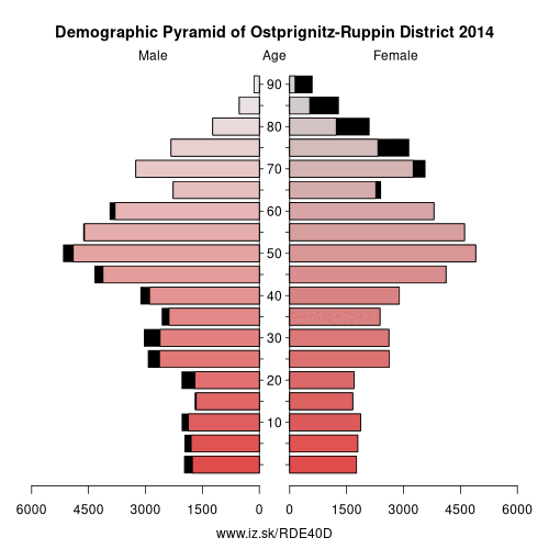
Demographics
| Indicator | Period | Value |
|---|---|---|
| Demographics | ||
| number of inhabitants | 2025 | 99 152 |
| population density | 2024 | 40.1 |
| old-age dependency ratio | 2025 | 48.9 |
From Wikipedia : Ostprignitz-Ruppin is a Kreis (district) in the northwestern part of Brandenburg, Germany. Neighboring are (from north clockwise) the districts Müritz and Mecklenburg-Strelitz in Mecklenburg-Western Pomerania, the districts
Oberhavel and Havelland, the district Stendal in Saxony-Anhalt, and the district Prignitz.Geography
The district consists of plain countryside northwest of Berlin. It is densely forested. Many rivers and lakes can be found in its western, its central and its northeastern part. The main river in the district is the Dosse.
History
The district has always been distinguishable from the West Prignitz, having been settled originally by Slavs from a different part of Mecklenburg. It was officially created in 1993 by merging the districts Kyritz, Neuruppin and Wittstock. The district roughly covers the same territory as the two historic districts Ostprignitz and Ruppin. Osprignitz was created in 1815 as one of two districts covering the former county Prignitz, and was split into the districts Kyritz, Pritzwalk and Wittstock in 1952.
Other: Brandenburg, Frankfurt (Oder), Märkisch-Oderland District, Oberhavel District, Barnim District, Ostprignitz-Ruppin District, Potsdam-Mittelmark District, Prignitz District, Brandenburg an der Havel, Cottbus, Uckermark District, Dahme-Spreewald District, Elbe-Elster District, Havelland District, Oberspreewald-Lausitz District, Spree-Neiße District, Potsdam, Teltow-Fläming District, Oder-Spree District
Neighbours: Stendal District, Ludwigslust-Parchim District, Mecklenburgische Seenplatte District, Havelland District, Prignitz District, Oberhavel District
Suggested citation: Michal Páleník: Europe and its regions in numbers - Ostprignitz-Ruppin District – DE40D, IZ Bratislava, retrieved from: https://www.iz.sk/PDE40D, ISBN: 978-80-970204-9-1, DOI:10.5281/zenodo.10200164
 Share
Share Facebook
 Twitter
 News
News