Havelland District – DE408
EU regions: Germany > Brandenburg > Brandenburg > Havelland District
| Indicator | Period | Value |
|---|---|---|
| Gross domestic product | ||
| GDP per capita in PPS of EU average | 2023 | 60 |
Havelland District slovensky: DE408
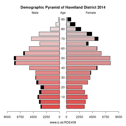
Demographics
| Indicator | Period | Value |
|---|---|---|
| Demographics | ||
| number of inhabitants | 2025 | 170 834 |
| population density | 2024 | 99.8 |
| old-age dependency ratio | 2025 | 38.6 |
Other: Brandenburg, Oberhavel District, Cottbus, Frankfurt (Oder), Barnim District, Ostprignitz-Ruppin District, Potsdam-Mittelmark District, Prignitz District, Brandenburg an der Havel, Märkisch-Oderland District, Uckermark District, Dahme-Spreewald District, Elbe-Elster District, Havelland District, Oberspreewald-Lausitz District, Spree-Neiße District, Potsdam, Teltow-Fläming District, Oder-Spree District
Neighbours: Potsdam-Mittelmark District, Berlin, Stendal District, Oberhavel District, Brandenburg an der Havel, Jerichower Land, Potsdam, Ostprignitz-Ruppin District
Suggested citation: Michal Páleník: Europe and its regions in numbers - Havelland District – DE408, IZ Bratislava, retrieved from: https://www.iz.sk/PDE408, ISBN: 978-80-970204-9-1, DOI:10.5281/zenodo.10200164
 Share
Share Facebook
 Twitter
 News
News