Teltow-Fläming District – DE40H
EU regions: Germany > Brandenburg > Brandenburg > Teltow-Fläming District
| Indicator | Period | Value |
|---|---|---|
| Gross domestic product | ||
| GDP per capita in PPS of EU average | 2023 | 101 |
Teltow-Fläming District slovensky: DE40H
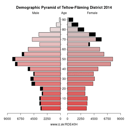
Demographics
| Indicator | Period | Value |
|---|---|---|
| Demographics | ||
| number of inhabitants | 2025 | 177 688 |
| population density | 2024 | 85 |
| old-age dependency ratio | 2025 | 37.8 |
From Wikipedia : Teltow-Fläming is a Kreis (district) in the southwestern part of Brandenburg, Germany. Neighboring districts are (from the east clockwise) Dahme-Spreewald, Elbe-Elster, the districts Wittenberg in Saxony-Anhalt, the district Potsdam-Mittelmark, and the Bundesland Berlin.
Geography
The district is named after the two main regions. The Teltow is an agricultural belt south of Berlin. The Fläming is a wooded hill chain in the south; the portion located in this district is called the Lower Fläming, while the Higher Fläming is situated in Potsdam-Mittelmark.
History
The district was formed in December 1993 by merging the previous districts Luckenwalde, Jüterbog and Zossen, but also including small parts from other former districts such as Luckau.
Demography
Miscellaneous
In the time from 1997 to 2001, the district had the biggest increase in the gross economic product of all districts of Germany with a rate of +56.1 %.[1] Flaeming-Skate is a 160 km (99 mi) long route specially for inline skating, the only such route in Germany. Curiously, the town of Teltow is not a part of the district Teltow-Fläming, just as the town of Dahme is not a part of the district of Dahme-Spreewald.
Other: Brandenburg, Frankfurt (Oder), Märkisch-Oderland District, Oberhavel District, Barnim District, Ostprignitz-Ruppin District, Potsdam-Mittelmark District, Prignitz District, Brandenburg an der Havel, Cottbus, Uckermark District, Dahme-Spreewald District, Elbe-Elster District, Havelland District, Oberspreewald-Lausitz District, Spree-Neiße District, Potsdam, Teltow-Fläming District, Oder-Spree District
Neighbours: Potsdam-Mittelmark District, Dahme-Spreewald District, Berlin, Wittenberg, Elbe-Elster District
Suggested citation: Michal Páleník: Europe and its regions in numbers - Teltow-Fläming District – DE40H, IZ Bratislava, retrieved from: https://www.iz.sk/PDE40H, ISBN: 978-80-970204-9-1, DOI:10.5281/zenodo.10200164
 Share
Share Facebook
 Twitter
 News
News