Barnim District – DE405
EU regions: Germany > Brandenburg > Brandenburg > Barnim District
| Indicator | Period | Value |
|---|---|---|
| Gross domestic product | ||
| GDP per capita in PPS of EU average | 2023 | 63 |
Barnim District slovensky: DE405
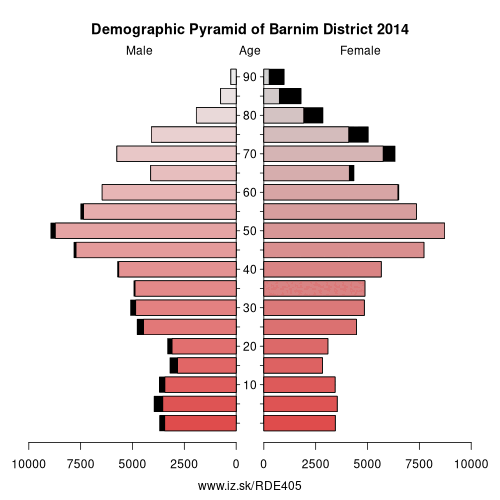
Demographics
| Indicator | Period | Value |
|---|---|---|
| Demographics | ||
| number of inhabitants | 2025 | 194 169 |
| population density | 2024 | 134.9 |
| old-age dependency ratio | 2025 | 42.6 |
From Wikipedia : Barnim is a district in Brandenburg, Germany. It is bounded by (from the east and clockwise) Poland, the district of Märkisch-Oderland, the city state of Berlin and the districts of Oberhavel and Uckermark.
History
The name „Barnim" emerged in the 13th century and was applied to a large forest region east of the Havel and north of the Spree on the homonymous plateau, where noblemen used to hunt. The present district is roughly identical with, but somewhat smaller than this historical region.
The district was established in 1993 by merging the former districts of Bernau and Eberswalde.
Geography
Barnim extends from the Oder River to the outskirts of Berlin. The Oder River forms the eastern border. From here the Oder Havel Canal (connecting Oder and Havel) and the historical Finow Canal lead westwards to Eberswalde and beyond. The portions north of these artificial waterways are called Schorfheide. This is a forest region with several large lakes, e.g.
Other: Brandenburg, Frankfurt (Oder), Barnim District, Märkisch-Oderland District, Oberhavel District, Ostprignitz-Ruppin District, Potsdam-Mittelmark District, Prignitz District, Brandenburg an der Havel, Cottbus, Uckermark District, Dahme-Spreewald District, Elbe-Elster District, Havelland District, Oberspreewald-Lausitz District, Spree-Neiße District, Potsdam, Teltow-Fläming District, Oder-Spree District
Neighbours: Uckermark District, Berlin, Szczeciński, Oberhavel District, Märkisch-Oderland District
Suggested citation: Michal Páleník: Europe and its regions in numbers - Barnim District – DE405, IZ Bratislava, retrieved from: https://www.iz.sk/PDE405, ISBN: 978-80-970204-9-1, DOI:10.5281/zenodo.10200164
 Share
Share Facebook
 Twitter
 News
News