Nordfriesland district – DEF07
EU regions: Germany > Schleswig-Holstein > Schleswig-Holstein > Nordfriesland district
| Indicator | Period | Value |
|---|---|---|
| Gross domestic product | ||
| GDP per capita in PPS of EU average | 2023 | 107 |
Nordfriesland district slovensky: DEF07
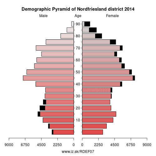
Demographics
| Indicator | Period | Value |
|---|---|---|
| Demographics | ||
| number of inhabitants | 2025 | 170 029 |
| population density | 2024 | 82.8 |
| old-age dependency ratio | 2025 | 41.7 |
Other: Schleswig-Holstein, Segeberg District, Kreis Pinneberg, Lübeck, District of Duchy of Lauenburg, Flensburg, Nordfriesland district, Rendsburg, Neumünster, Mittelangeln, Stormarn, Dithmarschen, Plön District, Ostholstein, Kiel, Steinburg
Neighbours: Southern Jutland, Mittelangeln, Dithmarschen
Suggested citation: Michal Páleník: Europe and its regions in numbers - Nordfriesland district – DEF07, IZ Bratislava, retrieved from: https://www.iz.sk/PDEF07, ISBN: 978-80-970204-9-1, DOI:10.5281/zenodo.10200164
https://www.iz.sk/en/projects/eu-regions/DEF07
 Share
Share Facebook
 Twitter
 News
News