Solingen – DEA19
EU regions: Germany > North Rhine-Westphalia > Düsseldorf Government Region > Solingen
| Indicator | Period | Value |
|---|---|---|
| Gross domestic product | ||
| GDP per capita in PPS of EU average | 2023 | 78 |
Solingen slovensky: DEA19
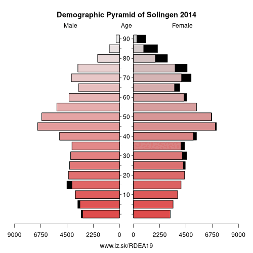
Demographics
| Indicator | Period | Value |
|---|---|---|
| Demographics | ||
| number of inhabitants | 2025 | 165 626 |
| population density | 2024 | 1842.8 |
| old-age dependency ratio | 2025 | 35.1 |
From Wikipedia : Solingen (German pronunciation: [ˈzoːlɪŋən] (listen)) is a city in North Rhine-Westphalia, Germany. It is located on the northern edge of the region called Bergisches Land, south of the Ruhr area, and, with a 2009 population of 161,366, is after Wuppertal the second largest city in the Bergisches Land. It is a member of the regional authority of the Rhineland.
Solingen is called the „City of Blades“, since it has long been renowned for the manufacturing of fine swords, knives, scissors and razors made by famous firms such as WKC, DOVO, Wüsthof, Zwilling J. A. Henckels, Böker, Hubertus, Diefenthal, Puma, Clauberg, Eickhorn, Linder, Carl Schmidt Sohn, Dreiturm, and numerous other manufacturers.
In Medieval times, the swordsmiths of Solingen coined the town's image, which is preserved to this date. In the latter part of the 17th century, a group of swordsmiths from Solingen broke their guild oaths by taking their sword-making secrets with them to Shotley Bridge, County Durham in England.
Geography
Solingen lies southwest of Wuppertal in the Bergisches Land. The city has an area of 89.45 square kilometres (34.54 sq mi), of which roughly 50 % is used for agriculture, horticulture, or forestry. The city's border is 62 kilometres (39 mi) long, and the city's dimensions are 15.6 kilometres (9.7 mi) east to west and 11.7 kilometres (7.3 mi) north to south. The Wupper river, a right tributary of the Rhine, flows through the city for 26 kilometres (16 mi).
Other: Düsseldorf Government Region, Remscheid, Essen, Rhein-Kreis Neuss, Wesel, Duisburg, Kleve, Mettmann, Düsseldorf, Wuppertal, Oberhausen, Mülheim an der Ruhr, Krefeld, Viersen, Mönchengladbach, Solingen
Neighbours: Wuppertal, Rhein-Berg District, Mettmann, Remscheid
Suggested citation: Michal Páleník: Europe and its regions in numbers - Solingen – DEA19, IZ Bratislava, retrieved from: https://www.iz.sk/PDEA19, ISBN: 978-80-970204-9-1, DOI:10.5281/zenodo.10200164
Similar articles
Navigation:
- Short news
- Local Administrative Units data of Visegrad countries open data
- Projects and activities
- European regions
- Random region: Hungary, Central Hungary, Budapest
 Share
Share Facebook
 Twitter
 News
News