Saxony – DED
| Indicator | Period | Value |
|---|---|---|
| Life long learning | ||
| life long learning participation | 2025 | 9.3 |
| Part time jobs and flexible employment | ||
| percentage of part time workers | 2025 | 31.73 |
| percentage of part time workers, men | 2025 | 15.84 |
| percentage of part time workers, women | 2025 | 49.49 |
| Gender differences | ||
| gender gap in employment rate | 2025 | 94.74 |
| gender gap in unemployment rate | 2025 | 86.27 |
| Graduates and young people | ||
| unemployment rate of youth with elementary education | 2019 | 10.4 |
| NEET | 2025 | 8.2 |
| Gross domestic product | ||
| GDP per capita in PPS of EU average | 2024 | 90 |
| Employment | ||
| employment rate | 2025 | 77.8 |
Saxony slovensky: DED
Subregions: Dresden Directorate District, Chemnitz Government Region, Leipzig Government Region
Unemployment
| Indicator | Period | Value |
|---|---|---|
| Unemployment | ||
| unemployment rate | 2025 | 4.9 |
| youth unemployment rate | 2025 | 9.1 |
| Long term unemployment | ||
| long term unemployment | 2025 | 2.1 |
| share of long term unemployed | 2025 | 44.2 |
Demographics
| Indicator | Period | Value |
|---|---|---|
| Demographics | ||
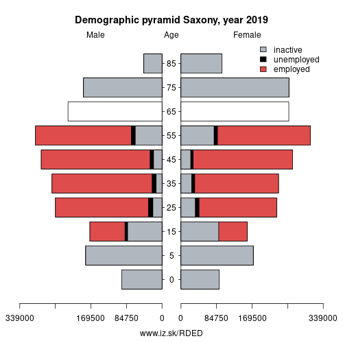
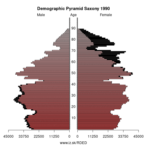
| number of inhabitants | 2025 | 4 042 422 |
| population density | 2024 | 222.7 |
| old-age dependency ratio | 2025 | 45.5 |
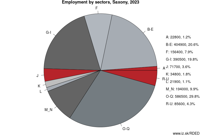
Employment by sectors, Saxony
| NACE r2 | % | NACE r2 | % | ||
|---|---|---|---|---|---|
| A | 14.7 | 1% | B-E | 370.5 | 19% |
| F | 129.9 | 7% | G-I | 381.7 | 20% |
| J | 73 | 4% | K | 37.5 | 2% |
| L | 14.1 | 1% | M_N | 202.9 | 11% |
| O-Q | 611 | 32% | R-U | 94 | 5% |
| TOTAL | 1929.4 | 100% |
Data for the period year 2025. Source of the data is Eurostat, table [lfst_r_lfe2en2].
From Wikipedia :
Saxony (German: Sachsen, Upper Sorbian: Sakska) is a landlocked federal state of Germany, bordering the federal states of Brandenburg, Saxony Anhalt, Thuringia, and Bavaria, as well as the countries of Poland (Lower Silesian and Lubusz Voivodeships) and the Czech Republic (Karlovy Vary, Liberec, and Ústí nad Labem Regions). Its capital is Dresden, and its largest city is Leipzig.Saxony is the tenth largest of Germany's sixteen states, with an area of 18,413 square kilometres (7,109 sq mi), and the sixth most populous, with 4 million people.
The history of the state of Saxony spans more than a millennium. It has been a medieval duchy, an electorate of the Holy Roman Empire, a kingdom, and twice a republic.
The area of the modern state of Saxony should not be confused with Old Saxony, the area inhabited by Saxons. Old Saxony corresponds roughly to the modern German states of Lower Saxony, Saxony-Anhalt, and the Westphalian part of North Rhine-Westphalia.
Geography
Administration
Saxony is divided into 10 districts:
1. Bautzen (BZ)
3.
Other: Germany, Thuringia, Saarland, Saxony, Saxony-Anhalt, Baden-Württemberg, Hamburg, Berlin, North Rhine-Westphalia, Hesse, Bavaria, Mecklenburg-Vorpommern, Schleswig-Holstein, Brandenburg, Rhineland-Palatinate, Bremen, Lower Saxony
Neighbours: MAKROREGION POŁUDNIOWO-ZACHODNI, Brandenburg, Saxony-Anhalt, Thuringia, Bavaria, Czech Republic, MAKROREGION PÓŁNOCNO-ZACHODNI
Subregions: Dresden Directorate District, Chemnitz Government Region, Leipzig Government Region
Suggested citation: Michal Páleník: Europe and its regions in numbers - Saxony – DED, IZ Bratislava, retrieved from: https://www.iz.sk/PDED, ISBN: 978-80-970204-9-1, DOI:10.5281/zenodo.10200164
 Share
Share Facebook
 Twitter
 News
News