Erfurt – DEG01
EU regions: Germany > Thuringia > Thuringia > Erfurt
| Indicator | Period | Value |
|---|---|---|
| Gross domestic product | ||
| GDP per capita in PPS of EU average | 2023 | 115 |
Erfurt slovensky: DEG01
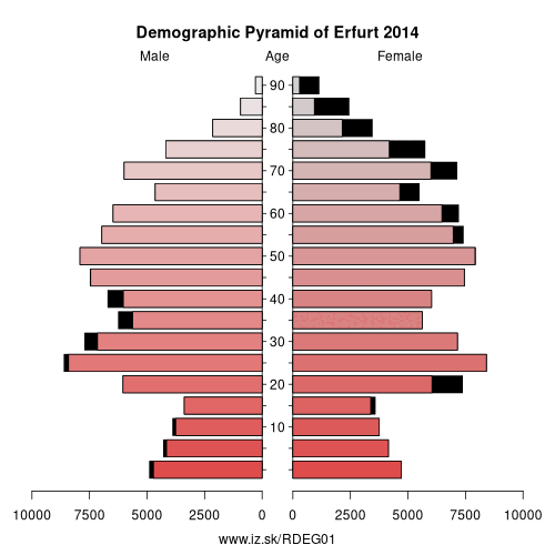
Demographics
| Indicator | Period | Value |
|---|---|---|
| Demographics | ||
| number of inhabitants | 2025 | 218 793 |
| population density | 2024 | 820.9 |
| old-age dependency ratio | 2025 | 36.8 |
From Wikipedia :
Erfurt ( AIR-furt, AIR-foort; German pronunciation: [ˈɛʁfʊʁt] (listen)) is the capital and largest city in the state of Thuringia, central Germany.Erfurt lies in the southern part of the Thuringian Basin, within the wide valley of the Gera river. It is located 100 km (62 mi) south-west of Leipzig, 300 km (186 mi) south-west of Berlin, 400 km (249 mi) north of Munich and 250 km (155 mi) north-east of Frankfurt. Together with a string of neighbouring cities Gotha, Weimar, Jena and others, Erfurt forms the central metropolitan corridor of Thuringia called Thüringer Städtekette (German „Thuringian city chain") with over 500,000 inhabitants.
Erfurt's old town is one of the best preserved medieval city centres in Germany. Tourist attractions include the Krämerbrücke (Merchants' bridge), the Old Synagogue, the ensemble of Erfurt Cathedral and Severikirche (St Severus's Church) and Petersberg Citadel, one of the largest and best preserved town fortresses in Europe. The city's economy is based on agriculture, horticulture and microelectronics. Its central location has led to it becoming a logistics hub for Germany and central Europe. Erfurt hosts the second-largest trade fair in eastern Germany (after Leipzig) as well as the public television children's channel KiKa.
The city is situated on the Via Regia, a medieval trade and pilgrims' road network.
Other: Thuringia, Weimar, Gera, Eichsfeld, Kyffhäuserkreis, Schmalkalden-Meiningen, Sömmerda, Saale-Holzland-Kreis, Saale-Orla-Kreis, Greiz, Eisenach, Wartburgkreis, Landkreis Saalfeld-Rudolstadt, Altenburger Land, Ilm-Kreis, Suhl, Sonneberg, Unstrut-Hainich-Kreis, Jena, Hildburghausen, Weimarer Land, Nordhausen, Erfurt, Gotha
Neighbours: Ilm-Kreis, Sömmerda, Weimarer Land, Gotha
Suggested citation: Michal Páleník: Europe and its regions in numbers - Erfurt – DEG01, IZ Bratislava, retrieved from: https://www.iz.sk/PDEG01, ISBN: 978-80-970204-9-1, DOI:10.5281/zenodo.10200164
 Share
Share Facebook
 Twitter
 News
News