Gotha – DEG0C
EU regions: Germany > Thuringia > Thuringia > Gotha
| Indicator | Period | Value |
|---|---|---|
| Gross domestic product | ||
| GDP per capita in PPS of EU average | 2023 | 80 |
Gotha slovensky: DEG0C
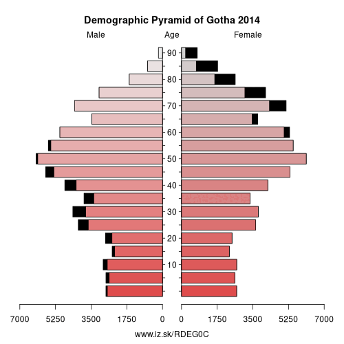
Demographics
| Indicator | Period | Value |
|---|---|---|
| Demographics | ||
| number of inhabitants | 2025 | 135 838 |
| population density | 2024 | 146.3 |
| old-age dependency ratio | 2025 | 45.3 |
Other: Thuringia, Weimar, Eichsfeld, Kyffhäuserkreis, Gera, Sömmerda, Saale-Holzland-Kreis, Schmalkalden-Meiningen, Saale-Orla-Kreis, Greiz, Eisenach, Wartburgkreis, Landkreis Saalfeld-Rudolstadt, Altenburger Land, Ilm-Kreis, Suhl, Sonneberg, Unstrut-Hainich-Kreis, Jena, Hildburghausen, Weimarer Land, Nordhausen, Erfurt, Gotha
Neighbours: Sömmerda, Erfurt, Wartburgkreis, Schmalkalden-Meiningen, Unstrut-Hainich-Kreis, Ilm-Kreis
Suggested citation: Michal Páleník: Europe and its regions in numbers - Gotha – DEG0C, IZ Bratislava, retrieved from: https://www.iz.sk/PDEG0C, ISBN: 978-80-970204-9-1, DOI:10.5281/zenodo.10200164
https://www.iz.sk/en/projects/eu-regions/DEG0C
 Share
Share Facebook
 Twitter
 News
News