Landkreis Saalfeld-Rudolstadt – DEG0I
EU regions: Germany > Thuringia > Thuringia > Landkreis Saalfeld-Rudolstadt
| Indicator | Period | Value |
|---|
Landkreis Saalfeld-Rudolstadt slovensky: DEG0I
Demographics
| Indicator | Period | Value |
|---|---|---|
| Demographics | ||
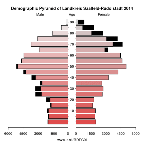
| number of inhabitants | 2023 | 101 494 |
| population density | 2022 | 98.4 |
| old-age dependency ratio | 2023 | 52.7 |
From Wikipedia : Saalfeld-Rudolstadt is a Kreis (district) in the south of Thuringia, Germany. Neighboring districts are (from the north clockwise) the districts Weimarer Land, Saale-Holzland, Saale-Orla, the district Kronach in Bavaria, and the districts Sonneberg, Hildburghausen and Ilm-Kreis.
History
The district dates back to the Landratsamt Saalfeld, which was created in 1868, and in 1922 it was converted into the Landkreis. Also in 1922 the district Rudolstadt was created, the second historical root of the district as of today. Both districts were merged in the communal reform of 1994.
Geography
The main rivers in the district is the Saale. The highest elevation is 827 m above sea level near Piesau, the lowest with 169 m is in the Saale river valley near Niederkrossen.
Other: Thuringia, Weimar, Eichsfeld, Kyffhäuserkreis, Sömmerda, Gera, Saale-Holzland-Kreis, Schmalkalden-Meiningen, Saale-Orla-Kreis, Greiz, Eisenach, Wartburgkreis, Landkreis Saalfeld-Rudolstadt, Altenburger Land, Ilm-Kreis, Suhl, Sonneberg, Unstrut-Hainich-Kreis, Jena, Hildburghausen, Weimarer Land, Nordhausen, Erfurt, Gotha
Neighbours: Weimarer Land, Ilm-Kreis, Sonneberg, Kronach, Saale-Orla-Kreis, Saale-Holzland-Kreis, Hildburghausen
Suggested citation: Michal Páleník: Europe and its regions in numbers - Landkreis Saalfeld-Rudolstadt – DEG0I, IZ Bratislava, retrieved from: https://www.iz.sk/PDEG0I, ISBN: 978-80-970204-9-1, DOI:10.5281/zenodo.10200164
 Share
Share Facebook
 Twitter
 News
News