Saale-Orla-Kreis – DEG0K
EU regions: Germany > Thuringia > Thuringia > Saale-Orla-Kreis
| Indicator | Period | Value |
|---|---|---|
| Gross domestic product | ||
| GDP per capita in PPS of EU average | 2023 | 84 |
Saale-Orla-Kreis slovensky: DEG0K
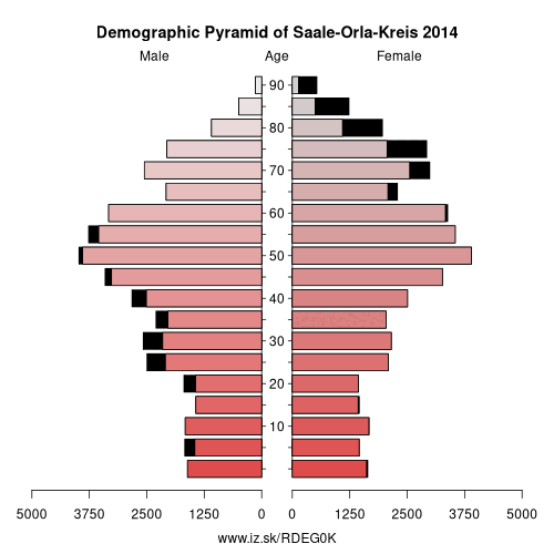
Demographics
| Indicator | Period | Value |
|---|---|---|
| Demographics | ||
| number of inhabitants | 2025 | 77 341 |
| population density | 2024 | 68.4 |
| old-age dependency ratio | 2025 | 51 |
From Wikipedia : Saale-Orla is a Kreis (district) in the east of Thuringia, Germany. Neighboring districts are (from the north clockwise) the districts Saale-Holzland, Greiz, the Vogtlandkreis in Saxony, the Bavarian districts Hof and Kronach, and the district Saalfeld-Rudolstadt.
History
The district was created in 1994 by merging the previous districts Lobenstein, Pößneck and Schleiz.
Geography
The main rivers in the district are the Saale and the Orla, which also contributed to the name of the district. The highest elevation with 732.9 m above sea level is the Sieglitzberg (near Lobenstein), the lowest with 180 m is near Schimmersburg Langenorla. The district is mountainous, covering the Thüringer Schiefergebirge. The dams of the Saale create the biggest system of artificial lakes in Germany.
Other: Thuringia, Weimar, Eichsfeld, Kyffhäuserkreis, Sömmerda, Saale-Holzland-Kreis, Gera, Schmalkalden-Meiningen, Saale-Orla-Kreis, Greiz, Eisenach, Wartburgkreis, Landkreis Saalfeld-Rudolstadt, Altenburger Land, Ilm-Kreis, Suhl, Sonneberg, Unstrut-Hainich-Kreis, Jena, Hildburghausen, Weimarer Land, Nordhausen, Erfurt, Gotha
Neighbours: Greiz, Landkreis Saalfeld-Rudolstadt, Kronach, Saale-Holzland-Kreis, Vogtlandkreis, Hof
Suggested citation: Michal Páleník: Europe and its regions in numbers - Saale-Orla-Kreis – DEG0K, IZ Bratislava, retrieved from: https://www.iz.sk/PDEG0K, ISBN: 978-80-970204-9-1, DOI:10.5281/zenodo.10200164
 Share
Share Facebook
 Twitter
 News
News