Montenegro – ME00
EU regions: Montenegro > Montenegro > Montenegro
| Indicator | Period | Value |
|---|---|---|
| Life long learning | ||
| life long learning participation | 2020 | 2.7 |
| Part time jobs and flexible employment | ||
| percentage of part time workers | 2020 | 4.2 |
| percentage of part time workers, men | 2020 | 4.65 |
| percentage of part time workers, women | 2020 | 3.64 |
| Gender differences | ||
| gender gap in employment rate | 2020 | 79.14 |
| gender gap in unemployment rate | 2020 | 105.14 |
| Graduates and young people | ||
| unemployment rate of youth with elementary education | 2016 | 50.7 |
| NEET | 2020 | 21.1 |
| Gross domestic product | ||
| GDP per capita in PPS of EU average | 2024 | 53 |
| Employment | ||
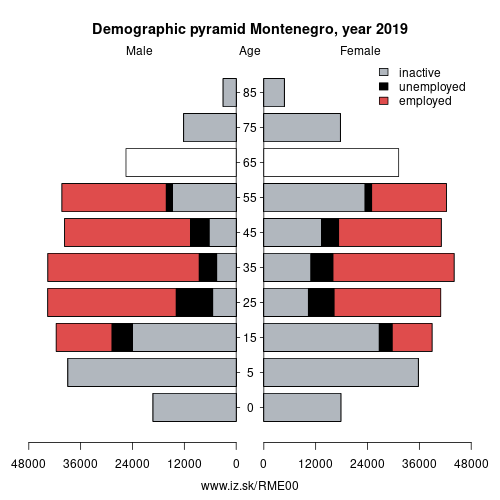
| employment rate | 2020 | 50.3 |
Montenegro slovensky: ME00
Subregions: Montenegro
Unemployment
| Indicator | Period | Value |
|---|---|---|
| Unemployment | ||
| unemployment rate | 2020 | 18.3 |
| youth unemployment rate | 2020 | 36 |
| Long term unemployment | ||
| long term unemployment | 2020 | 13.3 |
| share of long term unemployed | 2020 | 74.7 |
Demographics
| Indicator | Period | Value |
|---|---|---|
| Demographics | ||
| number of inhabitants | 2025 | 623 327 |
| population density | 2024 | 45.8 |
| old-age dependency ratio | 2025 | 26.6 |
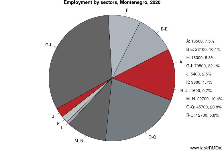
Employment by sectors, Montenegro
| NACE r2 | % | NACE r2 | % | ||
|---|---|---|---|---|---|
| A | 16.5 | 8% | B-E | 22.1 | 10% |
| F | 18.3 | 8% | G-I | 70.5 | 32% |
| J | 5.4 | 2% | K | 3.8 | 2% |
| L | 1.6 | 1% | M_N | 22.7 | 10% |
| O-Q | 45.7 | 21% | R-U | 12.7 | 6% |
| TOTAL | 219.4 | 100% |
Data for the period year 2020. Source of the data is Eurostat, table [lfst_r_lfe2en2].
From Wikipedia : Montenegro ( (listen); Montenegrin: Црна Гора, lit. 'Black Mountain', pronounced [tsr̩̂ːnaː ɡǒra]) is a country in Southeastern Europe. It is located on the Adriatic Sea and is a part of the Balkans, sharing borders with Serbia to the northeast, Bosnia and Herzegovina to the north and west, Kosovo to the east, Albania to the southeast, and the Adriatic Sea and Croatia to the southwest. Podgorica, the capital and largest city, covers 10.4 % of Montenegro's territory of 13,812 square kilometres (5,333 sq mi), and is home to roughly 30 % of its total population.
During the Early Medieval period, three principalities were located on the territory of modern-day Montenegro: Duklja, roughly corresponding to the southern half; Travunia, the west; and Rascia proper, the north. The Principality of Zeta emerged in the 14th and 15th centuries. From the late 14th century to the late 18th century, large parts of southern Montenegro were ruled by the Venetian Republic and incorporated into Venetian Albania. The name Montenegro was first used to refer to the country in the late 15th century. After falling under Ottoman rule, Montenegro regained its independence in 1696 under the rule of the House of Petrović-Njegoš, first as a theocracy and later as a secular principality. Montenegro's independence was recognized by the Great Powers at the Congress of Berlin in 1878. In 1910, the country became a kingdom. After World War I, it became part of Yugoslavia.
Other: Montenegro, Montenegro
Neighbours: North Albania, Šumadija and Western Serbia, Adriatic Croatia
Subregions: Montenegro
Suggested citation: Michal Páleník: Europe and its regions in numbers - Montenegro – ME00, IZ Bratislava, retrieved from: https://www.iz.sk/PME00, ISBN: 978-80-970204-9-1, DOI:10.5281/zenodo.10200164
 Share
Share Facebook
 Twitter
 News
News