Apulia – ITF4
EU regions: Italy > South Italy > Apulia
| Indicator | Period | Value |
|---|---|---|
| Life long learning | ||
| life long learning participation | 2025 | 8.2 |
| Part time jobs and flexible employment | ||
| percentage of part time workers | 2025 | 11.28 |
| percentage of part time workers, men | 2025 | 5.18 |
| percentage of part time workers, women | 2025 | 21.63 |
| Gender differences | ||
| gender gap in employment rate | 2025 | 59.03 |
| gender gap in unemployment rate | 2025 | 126.37 |
| Graduates and young people | ||
| unemployment rate of youth with elementary education | 2025 | 24.7 |
| NEET | 2025 | 13.9 |
| Gross domestic product | ||
| GDP per capita in PPS of EU average | 2024 | 64 |
| Employment | ||
| employment rate | 2025 | 51 |
| Social exclusion | ||
| people at risk of poverty or social exclusion | 2020 | 34.8 |
Apulia slovensky: ITF4
Subregions: Province of Taranto, Province of Brindisi, province of Lecce, Province of Foggia, Province of Bari, Province of Barletta-Andria-Trani
Unemployment
| Indicator | Period | Value |
|---|---|---|
| Unemployment | ||
| unemployment rate | 2025 | 10.3 |
| youth unemployment rate | 2025 | 32.6 |
| Long term unemployment | ||
| long term unemployment | 2025 | 6.1 |
| share of long term unemployed | 2025 | 60.8 |
Demographics

| Indicator | Period | Value |
|---|---|---|
| Demographics | ||
| number of inhabitants | 2025 | 3 877 395 |
| population density | 2024 | 201.3 |
| old-age dependency ratio | 2025 | 39 |
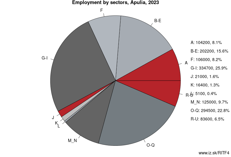
Employment by sectors, Apulia
| NACE r2 | % | NACE r2 | % | ||
|---|---|---|---|---|---|
| A | 109.2 | 8% | B-E | 196.2 | 15% |
| F | 100.6 | 8% | G-I | 325.1 | 25% |
| J | 27 | 2% | K | 17.2 | 1% |
| L | 4.7 | 0% | M_N | 137.2 | 11% |
| O-Q | 297.5 | 23% | R-U | 85.6 | 7% |
| TOTAL | 1300.3 | 100% |
Data for the period year 2025. Source of the data is Eurostat, table [lfst_r_lfe2en2].
From Wikipedia : Apulia ( ə-POO-lee-ə; Italian: Puglia [ˈpuʎːa]; Neapolitan: Pùglia [ˈpuʝːə]; Albanian: Pulia; Ancient Greek: Ἀπουλία, romanized: Apoulía) is a region in Southern Italy bordering the Adriatic Sea to the east, the Ionian Sea to the southeast, and the Strait of Otranto and Gulf of Taranto to the south. The region comprises 19,345 square kilometers (7,469 sq mi), and its population is about four million.
It is bordered by the other Italian regions of Molise to the north, Campania to the west, and Basilicata to the southwest. Across the Adriatic and Ionian Seas, it faces Albania, Bosnia-Herzegovina, Croatia, Greece, and Montenegro. Its capital city is Bari.
Geography
Apulia's coastline is longer than that of any other mainland Italian region. In the north, the Gargano promontory extends out into the Adriatic like a 'sperone' ("spur"), while in the south, the Salento peninsula forms the 'tacco' ("heel") of Italy's boot. The highest peak in the region is Mount Cornacchia (1,152 meters above sea level) within the Daunian Mountains, in the north along the Apennines.
It is home to two national parks, the Alta Murgia National Park and Gargano National Park.
Outside of national parks in the North and West, most of Apulia and particularly Salento is geographically flat with only moderate hills.
The climate is typically mediterranean with hot, dry and sunny summers and mild, rainy winters.
Other: South Italy, Abruzzo, Calabria, Basilicata, Campania, Apulia, Molise
Neighbours: Basilicata, Campania, Molise
Subregions: Province of Taranto, Province of Brindisi, province of Lecce, Province of Foggia, Province of Bari, Province of Barletta-Andria-Trani
Suggested citation: Michal Páleník: Europe and its regions in numbers - Apulia – ITF4, IZ Bratislava, retrieved from: https://www.iz.sk/PITF4, ISBN: 978-80-970204-9-1, DOI:10.5281/zenodo.10200164
 Share
Share Facebook
 Twitter
 News
News